Dutch Town Houten Routes Cars to Ring Road to Reach 70% Bike Share
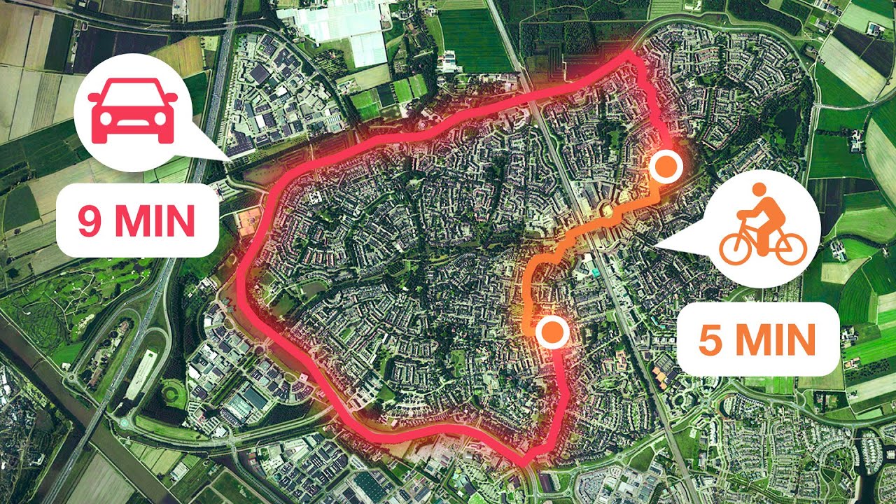
The Best-Designed Town in the Netherlands (and therefore, the world) — Not Just Bikes

Not Just Bikes

Restricting automobile through-traffic to peripheral ring roads allows suburbs to achieve up to ten times typical density while shifting 70% of local trips to bicycles.

AI-assisted summary of The Best-Designed Town in the Netherlands (and therefore, the world) — original source. Check the original for full context.

Source published:

Key ideas

  • Houten channels all intra-town vehicle traffic onto an exterior ring road, while direct interior routes are reserved exclusively for walking and cycling, driving over 70% of local trips onto bicycles. (0:00)
  • Within the area enclosed by its outer ring road, Houten achieves a residential density exceeding 5,000 people per square kilometer—four to ten times denser than conventional North American suburbs. (22:34)
  • The entire master-planned cycling network operates without a single traffic light, relying on grade-separated ring-road underpasses and bi-directional bike roundabouts to maintain uninterrupted flow. (11:50)
  • While intra-town active transit thrives, public bus transit suffers under the same ring-road detour restrictions as private cars, leading to slow journeys and headways up to 30 minutes. (17:31)

Detailed notes

## Background Published on YouTube by Not Just Bikes on June 30, 2025, this video explores the design and layout of Houten, a master-planned Dutch municipality outside Utrecht. The show notes highlight a crowdfunding effort to publish a bilingual book about Houten's planning history, channel support options across Patreon and Nebula, and reference material documenting the town's safety and development.

## TL;DR Host Jason Slaughter explores Houten, a master-planned municipality outside Utrecht engineered around human-scale mobility and the Dutch concept of *autoluw*. By routing motor vehicle through-traffic onto a peripheral ring road and weaving direct, grade-separated green corridors through the interior, Houten achieves a 70% bicycle commute share and an exceptionally safe environment for children and seniors. While acknowledging specific drawbacks such as detour-heavy bus transit, a lackluster secondary station at Castellum, and speeding mopeds on cycleways, Slaughter argues that Houten serves as a scalable, high-density suburban blueprint that disproves the perceived necessity of car-dependent sprawl.

## Atmosphere & style The presentation carries Not Just Bikes' hallmark blend of sharp, dry humor, incisive transit critique, and infectious enthusiasm for practical human-scale design. Touring through tree-lined linear paths and vibrant, car-free squares, Slaughter's tone oscillates between genuine delight at the town's effortless tranquility and exasperated mockery of North American zoning dogmas. The narrative feels lucid, grounded, and persuasive, conveying the profound sensory contrast between noisy arterial traffic and an intentionally quiet, child-friendly suburban community.

## Bulletin - [00:00](https://www.youtube.com/watch?v=r-TuGAHR78w&t=0s) Houten channels all intra-town vehicle traffic onto an exterior ring road, while direct interior routes are reserved exclusively for walking and cycling, driving over 70% of local trips onto bicycles. - [22:34](https://www.youtube.com/watch?v=r-TuGAHR78w&t=1354s) Within the area enclosed by its outer ring road, Houten achieves a residential density exceeding 5,000 people per square kilometer—four to ten times denser than conventional North American suburbs. - [11:50](https://www.youtube.com/watch?v=r-TuGAHR78w&t=710s) The entire master-planned cycling network operates without a single traffic light, relying on grade-separated ring-road underpasses and bi-directional bike roundabouts to maintain uninterrupted flow. - [17:31](https://www.youtube.com/watch?v=r-TuGAHR78w&t=1051s) While intra-town active transit thrives, public bus transit suffers under the same ring-road detour restrictions as private cars, leading to slow journeys and headways up to 30 minutes.

## Key takeaways - [00:00](https://www.youtube.com/watch?v=r-TuGAHR78w&t=0s) Houten uses an inverted street hierarchy where walking and cycling routes cut straight through town, while motor vehicles must take the long way around via an exterior ring road. - [01:41](https://www.youtube.com/watch?v=r-TuGAHR78w&t=101s) Developed from a small rural village of 4,000 into a master-planned municipality of over 50,000, Houten was constructed across two distinct circular lobes, each centered on a heavy-rail train station. - [02:57](https://www.youtube.com/watch?v=r-TuGAHR78w&t=177s) Houten is not car-free but 'autoluw', a Dutch design philosophy where car ownership and limited access are accommodated while motor traffic is systematically deprioritized. - [06:56](https://www.youtube.com/watch?v=r-TuGAHR78w&t=416s) Residential row houses are oriented to face directly onto linear greenway paths, keeping motor vehicle access and parking tucked away in rear alleys and courtyards. - [08:34](https://www.youtube.com/watch?v=r-TuGAHR78w&t=514s) The town incorporates a wide range of 'missing middle' housing types alongside detached homes, enabling lifecycle neighborhood stability without typical suburban sprawl. - [10:32](https://www.youtube.com/watch?v=r-TuGAHR78w&t=632s) Modal filters prevent residential streets from being used as throughways, ensuring neighborhood car traffic remains limited strictly to immediate residents. - [11:50](https://www.youtube.com/watch?v=r-TuGAHR78w&t=710s) The cycling infrastructure eliminates crossing friction and traffic lights entirely through extensive grade separation, including subterranean bicycle roundabouts beneath ring-road interchanges. - [13:15](https://www.youtube.com/watch?v=r-TuGAHR78w&t=795s) Complete elimination of through-traffic hazards affords local children rare independent mobility to cycle safely across town to school and activities without adult chauffeurs. - [13:55](https://www.youtube.com/watch?v=r-TuGAHR78w&t=835s) Commercial and light-industrial districts feature dual frontages with direct cycle network access and compact parking footprints supported by high active transit commute shares. - [17:31](https://www.youtube.com/watch?v=r-TuGAHR78w&t=1051s) The primary structural design flaw in Houten is regional bus transit, which is relegated to the outer ring road and suffers from long detours and 30-minute headways. - [19:38](https://www.youtube.com/watch?v=r-TuGAHR78w&t=1178s) High-speed motorized mopeds and scooters legally permitted on bicycle paths represent the town's greatest ongoing safety hazard and public nuisance. - [21:08](https://www.youtube.com/watch?v=r-TuGAHR78w&t=1268s) North American cities were bulldozed rather than inherently designed for cars; catering to vehicle geometry naturally destroys walkable human scale unless deliberately restricted. - [22:34](https://www.youtube.com/watch?v=r-TuGAHR78w&t=1354s) Houten serves as a universally replicable blueprint: encircling suburban transit stops every two kilometers with ring roads and car-free interior spines creates dense, livable communities.

## Detailed walkthrough ### [00:00](https://www.youtube.com/watch?v=r-TuGAHR78w&t=0s) The Philosophy of Houten

Houten is a town located just outside Utrecht in the Netherlands, recognized nationwide as one of the country's premier cycling environments—an impressive distinction given the high standard of Dutch bicycle infrastructure. Unlike cities retrofitted to accommodate bikes, Houten was deliberately planned from its inception around human-scale living, abundant greenery, and slow traffic.

The core traffic concept behind Houten is elegantly straightforward: intra-town journeys are direct, swift, and pleasant on foot or by bicycle. Driving across town, however, requires motorists to exit their immediate neighborhood, travel onto an outer ring road, and circle around to re-enter their destination quadrant. Because driving takes the long way around, walking and cycling are almost always faster and more convenient, naturally guiding modal choice.

```mermaid flowchart TD accTitle: Houten Traffic Routing Concept accDescr: Diagram illustrating how cyclists travel directly through the town center while motor vehicles are forced onto an outer ring road.

subgraph Internal ["Internal Movement"] Origin["Origin Neighborhood"] Dest["Destination Neighborhood"] BikePath["Direct Greenways & Cycle Paths"] end

subgraph External ["Motor Traffic Routing"] Ring["Outer Ring Road (Rondweg)"] end

Origin -->|"Walking / Cycling (Fast & Direct)"| BikePath BikePath --> Dest Origin -->|"Driving (Long Way Around)"| Ring Ring --> Dest ```

As a direct consequence of this layout, roughly 70% of all internal trips are made by bicycle, resulting in extraordinarily low motor vehicle volumes throughout the residential core. The speaker reflects on their own expectations prior to visiting:

> “I had heard for many years that Houten was a bicycle paradise, and I had it on my list of video topics since the beginning. But despite everything I had learned about it, I was still genuinely surprised at how nice it was to be there in person.”

- Over 70% of trips within Houten are made by bicycle. - The urban design specifically caters to families with young children by eliminating cut-through car traffic.

---

[01:41](https://www.youtube.com/watch?v=r-TuGAHR78w&t=101s) History, Structure, and Global Acclaim

Established as a municipality in the early 1800s, Houten remained a modest rural settlement of only about 4,000 residents until major development plans began in the 1970s. The town has since expanded to a population exceeding 50,000, meaning almost the entirety of its built environment is modern and intentionally planned.

Seen from above, Houten's footprint forms a distinct figure-eight comprised of two large circular sections. The northern lobe was planned first and built during the 1980s, while the southern lobe was constructed in the early 2000s under the same guiding design principles. Encircling both lobes is an exterior ring road—the only arterial road designed for through motor traffic. To serve regional transit needs, each lobe features its own centrally located railway station (Houten and Houten Castellum), giving a relatively small municipality two full rail stations.

Due to its global reputation, Houten employs an International Cycling Manager to handle professional inquiries. Annually, hundreds of urban planners, traffic engineers, and policymakers from around the globe visit to tour its cycling network and study its master planning.

---

[02:57](https://www.youtube.com/watch?v=r-TuGAHR78w&t=177s) Defining *Autoluw* vs. "Car-Free"

Houten's unique design often leads to semantic confusion abroad. The speaker recalls first encountering Houten over a decade ago on Wikipedia's “List of Car-Free Places,” only to quickly discover that the town was not actually car-free. Cars are permitted and owned, but the street layout keeps them subordinate. This confusion stems from the Dutch concept of *autoluw*, a term lacking a direct English equivalent that online tools often inaccurately render as "car-free."

While alternatives like "low-car" or "car-lite" are frequently used, the speaker prefers the phrasing adopted by urban mobility writer David Hembrow in a 2013 blog post:

> “Autoluw refers to places that prioritise walking and cycling but allow very limited access by motor vehicles.”

In an *autoluw* environment, internal vehicle access is strictly metered. Space is overwhelmingly dedicated to pedestrians and cyclists, while motorized access is primarily reserved for emergency services, public transport, delivery logistics, and resident parking access.

---

[04:30](https://www.youtube.com/watch?v=r-TuGAHR78w&t=270s) Arrival via Utrecht Centraal

Houten sits roughly 45 minutes away from Amsterdam. Reaching it involves taking an Intercity train from Amsterdam into Utrecht Centraal—the busiest railway hub in the Netherlands, accommodating roughly 200,000 daily transit users—followed by an 8-minute Sprinter ride directly into Houten.

The journey showcases Dutch spatial planning, where sharp urban boundaries prevent suburban sprawl. Within minutes of departing Utrecht's dense core, the train cuts through open agricultural fields before arriving directly in Houten. Upon pulling into Houten station, the immediate platform exit leads travelers straight into an underground bicycle parking garage equipped with OV-fiets shared rentals. While a transit-integrated bike facility of this caliber would be an extraordinary civic centerpiece outside the Netherlands, it functions here as standard public infrastructure.

---

[05:52](https://www.youtube.com/watch?v=r-TuGAHR78w&t=352s) First Impressions of Houten Centrum

Stepping out of the railway hub into Houten’s central square immediately upends car-dependent planning assumptions. The speaker was struck by the immediate vibrancy of the space:

> “When I stepped outside of the train station I literally started laughing. All of the bullshit excuses I’ve heard over the years of why we absolutely need car-dependent suburbs, all seemed completely absurd in the face of Houten.”

The central plaza functions as a thriving civic hub filled with everyday commerce, walkers, children on bicycles, seniors on mobility scooters, and riders on electric tricycles—all without a single car in sight. Despite its modest population, the public realm exhibits far more pedestrian life than car-dominated cities with ten times as many residents, disproving the notion that suburban commerce relies on surface parking and drive-up automobile access.

---

[06:56](https://www.youtube.com/watch?v=r-TuGAHR78w&t=416s) Linear Parks and Front Doors on Bike Paths

Moving westward away from the station, the town's spine unfolds through dedicated linear parks. The planners mandated that every resident live within immediate walking distance of green space. In the northern section, this took the shape of an east-to-west linear green corridor with branching offshoots; in the southern development, it was laid out as an interconnected pentagonal greenway system. These corridors double as grade-separated bicycle trunk routes, allowing residents to navigate across quadrants safely away from motor routes.

Bordering these linear parks are residential row houses built facing directly onto cycling paths rather than car lanes. Front doors open straight onto car-free communal green space, giving children a safe environment to play and travel without road danger.

```mermaid flowchart LR accTitle: Residential Block Orientation accDescr: Diagram showing rowhouses fronting directly onto cycling greenways, with motor vehicle parking kept at the rear.

subgraph Front ["Pedestrian & Cycle Realm"] Greenway["Linear Park & Main Cycle Path"] FrontDoor["Front Doors & Porches"] end

subgraph Housing ["Building Envelope"] Rowhomes["Rowhomes / Townhouses"] end

subgraph Rear ["Automobile Realm"] BackAccess["Rear Alleys & Parking Courts"] LocalStreet["Slow Local Access Street"] end

Greenway --- FrontDoor FrontDoor --- Rowhomes Rowhomes --- BackAccess BackAccess --- LocalStreet ```

Motor vehicles are not banned; instead, parking is tucked into shared courtyards or rear alleys served by low-speed access lanes disconnected from the primary bicycle network. Motorists park in these dedicated clusters rather than storing vehicles on through streets.

---

[08:34](https://www.youtube.com/watch?v=r-TuGAHR78w&t=514s) Housing Diversity and the "Missing Middle"

Houten integrates a wide spectrum of housing forms: small multi-family apartment buildings, attached townhouses, and detached single-family dwellings. This contrasts sharply with North American zoning conventions, where exclusive single-family detached zoning frequently outlawed the "missing middle" for decades, resulting in neighborhoods composed solely of detached tract houses or isolated high-rises.

A diverse housing stock supports lifecycle stability within the community: - Young adults and individuals moving into their first private homes can lease or buy compact flats. - Growing families can upsize to rowhouses or larger homes in the same district. - Empty nesters and seniors can downsize without abandoning their established social ties, friends, or local neighborhood roots.

Even the detached single-family residences in Houten avoid typical suburban traits like oversized through-streets and large ornamental front lawns. Single-family neighborhoods still connect directly into the cycling path network, allowing residents to enjoy detached housing while remaining an easy, safe bike ride from transit hubs.

---

[10:06](https://www.youtube.com/watch?v=r-TuGAHR78w&t=606s) Fietsstraten and Low-Stress Shared Spaces

The vast majority of residential roads within Houten’s inner sectors are designed as *fietsstraten* (bicycle streets). On these corridors, the roadway is asphalted in smooth red surfacing to visually and legally establish that cyclists have absolute priority:

> “These are streets where cyclists come first, and cars are considered ‘guests.’”

While shared-street initiatives in other global cities frequently lead to friction, aggressive passing, and driver frustration, they operate smoothly in Houten. Because the *autoluw* ring-road master plan keeps vehicular through-traffic out of neighborhoods, car volumes and vehicle speeds on these access ways remain consistently low, ensuring cars drive at the speed of cyclists without conflict.

[10:32](https://www.youtube.com/watch?v=r-TuGAHR78w&t=632s) Modal Filters and the Ring Road Network

In Houten, residential streets are engineered so that personal car ownership is fully accommodated without allowing vehicular traffic to degrade daily life. On an ordinary residential lane serving roughly ten houses, the only drivers present are the residents who live right there. Because most routine errands and local destinations are faster and easier to reach on foot or by bicycle, passing cars are an exceptional sight. The fundamental principle is that while residents can own cars and drive directly to their doorsteps, residential streets are physically barred from being used as throughways.

Any driver attempting to cut through the neighborhood quickly encounters a dead end created by a modal filter—a physical barrier that blocks four-wheeled motor vehicles while letting bicycles and pedestrians pass right through. To travel to another part of town or leave Houten altogether, drivers must loop outward onto the peripheral ring road and take an indirect path around the edge. Cyclists, by contrast, glide straight through the center along the shortest, most direct corridors. As Jason argues, “Blocking off cars like this is called a modal filter, and they are common all over the Netherlands, and they really should be commonplace in absolutely every city everywhere to prevent car traffic from consuming every street.” Emergency service vehicles maintain special access: they can bypass modal filters and are legally permitted to drive down bicycle paths when responding to urgent calls.

```mermaid flowchart TD accTitle: Travel Routing Comparison in Houten accDescr: Diagram illustrating how modal filters channel bicycles directly through greenways while cars are routed onto the outer ring road. subgraph Origin ["Residential Neighborhood"] Home["Neighborhood Homes"] Filter{"Modal Filter"} end subgraph Cycling ["Active Mobility Network"] Greenway["Linear Parks & Cycle Paths"] Center["Town Center / Train Station"] end subgraph Driving ["Motor Vehicle Network"] Ring["Outer Ring Road"] CarPark["Business / Center Parking"] end Home -->|"Bicycle / Foot"| Filter Filter -->|"Bicycles Pass Straight"| Greenway Greenway -->|"Direct & Unimpeded"| Center Home -->|"Drive"| Ring Ring -->|"Circumferential Detour"| CarPark ```

- Residents retain motor vehicle access to their front doors, but car traffic cannot cut between neighborhoods. - Modal filters ensure that cycling is consistently faster and more direct than driving for intra-town journeys. - First responders and emergency vehicles are granted exceptions to modal restrictions and can utilize wide cycleways during emergencies.

---

[11:50](https://www.youtube.com/watch?v=r-TuGAHR78w&t=710s) Seamless Cycling Infrastructure and Child Independence

Restricting car access is only half the formula; Houten also optimizes cycling to be exceptionally fast and fluid. The dedicated cycling network operates entirely without traffic signals. Because bicycles do not create the hazardous cross-traffic friction of multi-ton motor vehicles, traffic lights are completely unnecessary. Where cycle routes cross local streets, cyclists are granted legal and physical right-of-way, meaning riders almost never have to stop or lose forward momentum. Encounters between cars and bicycles are kept to an absolute minimum through extensive grade separation.

When cycle tracks meet the outer ring road, they dip smoothly beneath it. At one major ring-road junction, cars navigate an intensive motor vehicle roundabout on the surface, while directly underneath sits an entirely grade-separated subterranean cycling roundabout. Because bicycles possess far greater spatial maneuverability and tighter turning radii than automobiles, the lower roundabout is bi-directional; Dutch planners designed it for bicycles on their own terms rather than treating bicycle paths as scaled-down car lanes. These underpasses link seamlessly with the town’s linear parks, allowing riders to cross Houten from edge to edge without ever brushing against motor traffic.

Examining local traffic safety records, Jason highlights an intersection officially logged as one of the single most dangerous crossings in Houten. While it features minor visibility compromises by Dutch standards, the contrast with the rest of the world is staggering. Jason marveled at the baseline safety: “In my research, this intersection came up as one of the most dangerous intersections in all of Houten. Which. OK, there are a few issues here from a Dutch cycling point of view but … wow. I wish we could all live somewhere where this was as dangerous as it gets.”

This total elimination of traffic violence unlocks genuine personal independence for local children. Toddlers are carried to daycare in cargo bikes and child carriers, while older children ride their own bicycles autonomously from elementary school to after-school care without adult supervision. Jason forcefully emphasizes the developmental contrast with car-dependent societies: “If you can’t understand how this is a better way for children to grow up, compared to being shuttled around in cars, I don't know what to tell you.”

- Cycling traffic lights are non-existent in Houten because cycle-to-cycle flow regulates itself without signalization. - Underpasses beneath the ring road eliminate crossing hazards, including bi-directional bicycle roundabouts beneath car roundabouts. - High traffic safety gives children autonomy to travel across town without parents serving as chauffeurs.

---

[13:55](https://www.youtube.com/watch?v=r-TuGAHR78w&t=835s) Integrating Businesses and Commercial Areas

While Houten is primarily a bedroom community whose residents often commute to jobs in surrounding cities, it incorporates vibrant commercial and light-industrial districts. These employment centers sit both outside the perimeter ring road and within the interior ring itself, yet they avoid the hostile environments typical of suburban commercial parks. Buildings situated inside the ring road are designed with dual frontages: the road-facing side accommodates car access and delivery vehicles, while the back entrances open directly onto the separated cycling network.

Workers and customers arriving by bike can turn straight off a tree-lined path directly to the building entrance, bypassing vehicle roadways altogether. While businesses provide free surface parking for staff and visitors, the parking lots and access roads are noticeably compact. Because large shares of workers walk, cycle, or arrive by train, asphalt footprints can be drastically minimized. Comparing the area to the bleak, parking-cratered business parks of suburban Canada and the corporate office complexes near Amsterdam Airport, Jason singles out Houten’s 1980s business sector as the most pleasant and human-scaled he has ever encountered.

- Dual-frontage architecture connects delivery and vehicle parking on one side and bicycle access paths on the other. - Free vehicle parking is provided, but parking footprints remain small due to high bicycle, pedestrian, and transit commute shares. - Commercial areas remain pleasant and quiet rather than being overwhelmed by multi-lane distributor roads.

---

[15:23](https://www.youtube.com/watch?v=r-TuGAHR78w&t=923s) Architectural Whimsy, the Old Village, and the "Boring" Town Debate

Houten's construction took place across two principal eras. The initial 1980s expansion established the town's core master plan, while the second major phase, built in the early 2000s, embraced an eclectic range of architectural motifs. Along one of the town's retention lakes, planners erected brightly colored waterfront houses designed in the style of a traditional Scandinavian fishing village, skirted by an over-water cycling bridge. Nearby, the town's secondary railway station, Castellum, was built as a modern homage to a Roman fortification, complete with perimeter walls, water-filled moats, and bridge crossings acknowledging the region's ancient Roman history. While unusual, these dramatic stylistic choices give neighborhoods recognizable identities and serve as universal meeting points.

At the historical heart of the municipality lies the original village of Houten, which maintains an entirely different, older character. Its narrow brick streets feel like an organic historic Dutch settlement, and vehicle traffic is visibly higher than in the master-planned districts. Nonetheless, the preserved historic village square retains a charming atmosphere, preserving the lineage of the rural parish around which the new town grew. The town's planning legacy is so rich that a collective of local residents joined forces with Houten's original designer to research, write, and publish a comprehensive bilingual book in Dutch and English.

Addressing the broader livability of the town, Jason acknowledges an ongoing critique raised by former residents who eventually moved away: the town is "too boring." He agrees with the premise, but frames it as an inevitable and deliberate quality of a quiet, child-friendly residential suburb:

> “It’s one thing to live in a town that has several things to do, but not all of the amenities of a city, while also having regular train service that will take you somewhere more lively when you want it. Compared to living in suburbia where you are literally trapped in your local neighbourhood unless you have a car. And the most interesting thing you’ll ever likely to do is to decide which chain restaurant you want to eat at this week.”

- Phase two developments introduced varied architectural experiments, including Nordic-style waterfront housing and a Roman castle theme for Castellum. - The original village core was preserved intact, contrasting modern master-planned neighborhoods with a historic town center. - Former residents sometimes leave because the town lacks big-city nightlife, though rapid rail access connects residents to Utrecht and beyond within minutes.

---

[17:31](https://www.youtube.com/watch?v=r-TuGAHR78w&t=1051s) Flaws in Transit and the Frustration with Mopeds

Despite its world-class design, Houten is not without flaws. Its principal structural weakness lies in public bus transit. Every resident lives within a 20-minute walk or a 5-minute bike ride of one of the two railway stations, but local bus routing suffers under the same ring-road model imposed on private cars. Because standard transit buses are motor vehicles barred from using neighborhood modal filters, they are forced to make lengthy detours along the perimeter ring road. Consequently, bus stops are spaced far apart, intra-town bus journeys are sluggish, and headways on some routes stretch to 30 minutes. Jason notes that Houten could significantly benefit from dedicated tram corridors or light rail transit (LRT) cutting through the interior—similar to the transit lines serving neighboring municipalities linked to Utrecht. A small rail shuttle previously operated between the central station and Castellum, but it was discontinued once Castellum station was upgraded into a full heavy-rail stop on the national rail network.

The physical design around Castellum station also drew sharp criticism. Unlike the airy and inviting main station plaza, Castellum feels confined, shadowed, and uninviting. Town planners positioned the vehicle entrance to the underground parking garage directly underneath the station, bringing car traffic directly into what should be a pedestrianized core and leaving the under-track space cold and barren.

Jason's sharpest grievance, however, is the presence of motorized mopeds (*snorfietsen* and scooters) on the bicycle paths:

> “If Houten is not willing to do the same, then at the very least they need to set up average speed cameras on popular bicycle routes, because it’s absolutely ridiculous how fast people ride these motor scooters, even when there are little kids and elderly people around.”

While Amsterdam took steps to ban mopeds from most urban cycle tracks in 2019, Houten still permits them on primary bike corridors. The excessive speed and noise of gas and electric mopeds present a jarring, hazardous contrast in an environment designed for young children and seniors. Yet despite these drawbacks, returning to Amsterdam by train at the end of the day drove home just how unmatched Houten really is. After only a single afternoon riding on Houten's calm, autoluw streets and wide, tree-lined greenways completely divorced from traffic signals, cycling anywhere else felt markedly more stressful.

- Regional buses are restricted to the outer ring road, resulting in long detour times, infrequent 30-minute headways, and wide stop spacing. - Castellum station features a compromised public realm due to underground parking access ramps channeling vehicle traffic beneath the platforms. - High-speed mopeds on separated paths remain the single greatest nuisance and safety hazard on Houten's otherwise peaceful cycling network.

[21:08](https://www.youtube.com/watch?v=r-TuGAHR78w&t=1268s) The Myth of Pre-Car Cities and the Reality of Automobile Dominance

The idea that great urban design is strictly an ancient European phenomenon inaccessible to the modern world is an absurd claim. Plenty of exceptional places in Europe were built long after the automobile existed. Furthermore, virtually every American and Canadian city was originally built before cars dominated the landscape, featuring walkable neighborhoods linked by streetcar lines and anchored by a central passenger train station. As Jason Slaughter reiterates:

> “As I’ve said many times before, North American cities weren’t built for the car, they were bulldozed for the car.”

Historically, builders did not need a designated design discipline to create walkable cities; it was simply the inevitable, default outcome of constructing human settlements. The phrase "walkable cities" did not even exist because there was no alternative way to imagine building a place.

Everything changed when cars became ubiquitous. Because motor vehicles are massive and require enormous geometric space, catering to them directly destroys the human scale. Accommodating cars pushes destinations far apart, rendering them impossible to reach on foot and financially or operationally impractical to serve with public transit. Uncontrolled vehicular traffic introduces acute danger, discouraging cycling and walking because people feel unsafe outside of a steel shell, while also blanketed neighborhoods in localized noise and exhaust pollution. Left unchecked, cars expand to consume every bit of available surface area, crowding out everything else. Therefore, building functional urban environments for human beings is no longer possible unless city designers deliberately make the choice to restrict automobiles.

```mermaid flowchart TD accTitle: The Downward Spiral of Car-Centric Planning accDescr: Diagram illustrating how accommodating large motor vehicles degrades walkability, transit viability, and safety.

subgraph SpatialImpact["Spatial Demands"] A["Prioritizing Cars"] --> B["Sprawling Distances & Loss of Human Scale"] B --> C["Destruction of Walkability & Transit Viability"] end

subgraph EnvironmentalImpact["Quality of Life Impact"] A --> D["Traffic Danger, Noise, & Local Air Pollution"] D --> E["Deterrence of Walking & Cycling"] end

C --> F["Cars Consume All Available Urban Space"] E --> F F --> G["Human-Scale Urbanism Becomes Impossible Without Deliberate Restrictions"] ```

[22:34](https://www.youtube.com/watch?v=r-TuGAHR78w&t=1354s) Houten as a Universal Blueprint for Modern Suburbia

The fundamental lesson to draw from Houten is not an unrealistic demand to eliminate motor vehicles entirely, but to design around their realities. Automobiles are not going away, and motor vehicles remain genuinely useful tools in specific situations. Delivery vans are practical for moving bulky goods, and fire trucks are an indisputably good idea—a point Jason sarcastically labels a "burning hot take" before joking, "Somebody call the fire department."

```mermaid flowchart LR accTitle: Scalable Blueprint for Transit-Oriented Suburbs accDescr: Concept diagram showing how Houten's ring road and rail model can be replicated along any metro line.

subgraph Corridor["Rapid Transit Line"] M1["Metro Station A"] --- M2["Metro Station B (2 km spacing)"] --- M3["Metro Station C"] end

subgraph SatelliteUnit["Houten-Style Module"] M2 --> Core["High-Density Transit Core"] Core --> Paths["Pedestrian & Bicycle Green Spine"] Paths --> Ring["Exterior Peripheral Ring Road"] end ```

The success of Houten proves that density and livability can co-exist outside an ancient urban core. While the broader municipality encompasses vast agricultural land, the area enclosed by Houten’s peripheral ring road achieves a residential population density exceeding 5,000 people per square kilometer. This level of compactness is between four and ten times denser than a conventional car-dependent North American suburb, yet Houten remains vastly more pleasant to live in by a wide margin.

This model does not need to stay confined to satellite towns in the province of Utrecht; it represents a universally applicable suburban development pattern. Any city in the world could run a regional metro line with stations spaced roughly two kilometers apart, encircle each station with a Houten-style exterior ring road, and weave a car-free spine inside. Doing so would provide high-density suburban housing while creating a community superior to almost any conventional suburb ever constructed. As Jason reflects on the global implications:

> “Because the world would be so much better if every town and suburb was designed as well as Houten.”

- **Population Density**: Over 5,000 residents per square kilometer inside the ring road. - **Density Comparison**: 4 to 10 times higher than typical North American car-dependent suburban tracts. - **Replication Formula**: Metro or rail stations placed 2 kilometers apart, each surrounded by a multimodal exterior perimeter ring and an interior bicycle/pedestrian network.

[23:39](https://www.youtube.com/watch?v=r-TuGAHR78w&t=1419s) The Future Development of Houten and Channel Outro

With the Netherlands facing an ongoing national housing shortage, Houten is preparing its next major expansion. Active municipal planning and public debates are underway regarding the development of open land along the eastern edge of the town. While current project proposals appear promising, the original 1970s master designers are no longer at the helm, placing the responsibility on a new generation of urban planners to uphold the town's unique autoluw legacy. Jason emphasizes:

> “And urban planners everywhere should be watching this closely, and studying what elements made this small town internationally famous in the first place.”

The video closes with an invitation to support the channel. Viewers can support *Not Just Bikes* on Patreon to receive early access to upcoming content, or subscribe to Nebula for ad-free streaming, exclusive original series, and access to more than 200 other creators. Viewers can use a promotional discount link for 40% off an annual Nebula plan, with the option to pay via the Dutch domestic payment method iDEAL using Nebula digital gift cards.

- **Expansion Focus**: Future growth proposals are focused on the open land on the eastern edge of Houten. - **Support Links**: Early and ad-free access is offered through Patreon and Nebula. - **Dutch Payment Support**: Viewers looking to avoid international credit card fees can purchase Nebula subscriptions using iDEAL via Nebula gift cards.

## Notable quotes > [21:08](https://www.youtube.com/watch?v=r-TuGAHR78w&t=1268s) North American cities weren’t built for the car, they were bulldozed for the car. — Jason Slaughter

## Mentioned Houten, Utrecht, Amsterdam, Utrecht Centraal, Houten railway station, Houten Castellum, Jason Slaughter, Not Just Bikes, David Hembrow, OV-fiets, Patreon, Nebula, iDEAL, Het Utrechts Archief, Robert

## Video description Help publish the book about Houten! https://www.gofundme.com/f/cycling-city-Houten-says-hello-world

Support this channel on Patreon: Patreon: https://patreon.com/notjustbikes

Or sign up to Nebula for only $36/year with this link: https://go.nebula.tv/notjustbikes

Nebula gift cards (now with iDEAL): https://gift.nebula.tv/notjustbikes

Watch this video ad-free and sponsor-free on Nebula: https://nebula.tv/videos/notjustbikes-the-bestdesigned-town-in-the-netherlands-and-therefore-the-world

Patreon: https://patreon.com/notjustbikes Mastodon: @notjustbikes@notjustbikes.com NJB Live (my live-streaming channel): https://youtube.com/@njblive

--- Relevant videos

Car-free Streets are Amazing (and we need more of them) - Autoluw https://nebula.tv/videos/not-just-bikes-car-free-streets-are-amazing-and-we-need-more-of-them https://youtu.be/GlXNVnftaNs

How American Fire Departments are Getting People Killed https://youtu.be/j2dHFC31VtQ https://nebula.tv/videos/notjustbikes-how-american-fire-departments-are-getting-people-killed

Business Parks Suck (but they don’t have to) https://youtu.be/SDXB0CY2tSQ https://nebula.tv/videos/notjustbikes-business-parks-suck-but-they-dont-have-to

--- References & Further Reading

Waarom 'de hele wereld' komt fietsen in Houten https://www.rtvutrecht.nl/nieuws/3875045/waarom-de-hele-wereld-komt-fietsen-in-houten https://www.youtube.com/watch?v=NkyeMHaOta8

Nearly Car-Free Areas (A View from the Cycle Path) https://www.aviewfromthecyclepath.com/2013/02/nearly-car-free-areas.html

Robert (82) ‘bedacht’ het dorp Houten: ‘Trots is niet het goede woord. Ik ben vooral blij’ https://www.ad.nl/utrecht/robert-82-bedacht-het-dorp-houten-trots-is-niet-het-goede-woord-ik-ben-vooral-blij~ac3b3b6f/

Houten is relatief verkeersveilig, maar elk ongeval is er één te veel https://www.houtensnieuws.nl/lokaal/verkeer-en-vervoer/954333/houten-is-relatief-verkeersveilig-maar-elk-ongeval-is-er-een-#closemodal

Historical photos of Houten from Het Utrechts Archive Public domain or CC/BY: https://hetutrechtsarchief.nl/beeld/840CA54571E38187E0534701000AAB1C https://hetutrechtsarchief.nl/beeld/C03381F519EA566B974FBBD91028DA7F https://hetutrechtsarchief.nl/beeld/79666BC6E00A5D4E980430B7E869D3A8 https://hetutrechtsarchief.nl/beeld/119B82E056E55553A984C48CB009B65E https://hetutrechtsarchief.nl/beeld/4F97C35AC1A85804B7ED8166A8C7B762 https://hetutrechtsarchief.nl/beeld/40858864BBFD51BEA3DB81B3A0FB2FA5 https://hetutrechtsarchief.nl/beeld/52915A26122A5A4F961CE7B20DA451E2 https://hetutrechtsarchief.nl/beeld/8EC693301C655AD09E952483BC9A6E1A https://hetutrechtsarchief.nl/beeld/ECA62A8B3D0852B6A27EB542EA13B121 https://hetutrechtsarchief.nl/beeld/E3982DB6DA51565BBFD4D50DB8B41273 https://hetutrechtsarchief.nl/beeld/37092E42A9815783A98D94CC022CEA8B https://hetutrechtsarchief.nl/beeld/2EA67B58B88D579C84E101C5B2DCF6A4 https://hetutrechtsarchief.nl/beeld/D9DFFBE4936FA018E0538F04000AB4D4 https://hetutrechtsarchief.nl/beeld/03742848034755EEA1245BDFC7DE4665

Houten Tram Door Mauritsvink - Eigen werk, Publiek domein, https://commons.wikimedia.org/w/index.php?curid=5493396 Door T Houdijk, CC BY-SA 3.0, https://commons.wikimedia.org/w/index.php?curid=1810526 Door Steinbach (overleg · bijdragen) - zelf gefotografeerd, Publiek domein, https://commons.wikimedia.org/w/index.php?curid=820183 Door T Houdijk, CC BY-SA 3.0, https://commons.wikimedia.org/w/index.php?curid=1810530

The vast majority of the content in this video was filmed on location by Not Just Bikes, with some images licensed from Getty Images and other sources.

No generative AI or AI voices were used in the making of this video

--- Chapters 0:00 Intro 1:41 Houten history & context 2:57 Autoluw 4:30 Getting there from Amsterdam 5:13 The train station 5:52 Houten centrum 6:56 Linear parks 7:29 Houses bordering the bicycle paths 8:34 Different housing types 9:38 Quiet suburban residential streets 10:58 Modal filters 11:50 Fast and efficient cycling 13:15 Independence for children 13:55 Commercial spaces 15:21 Interesting architecture 16:09 The old villiage 16:27 The book about Houten 17:01 Is Houten ... perfect? 18:04 Public transit 19:09 Nitpicking 19:33 Those @#$*ing mopeds 20:34 Returning to Amsterdam 21:00 We need actively restrict cars 22:33 What we should learn from Houten 23:39 The future of Houten 24:17 How to support Not Just Bikes

[Source](https://www.youtube.com/watch?v=r-TuGAHR78w)

中文简报

荷兰小镇豪滕将汽车引流至环路,自行车出行占比达70% 将汽车过境交通限制在周边环路,使郊区密度可达常规水平的十倍,并将70%的本地出行转变为自行车出行。 主持人杰森·斯劳特(Jason Slaughter)探索了位于乌得勒支郊外的总体规划市镇豪滕(Houten)。该镇围绕人性化尺度的出行方式和荷兰的“少车”(autoluw)理念设计。通过将机动车过境交通引至外围环路,并在内部穿插直达且立体分流的绿色廊道,豪滕实现了70%的自行车通勤比例,并为儿童和老人营造了格外安全的环境。尽管斯劳特也指出了具体的弊端,如公交车绕行严重、卡斯特伦(Castellum)次级火车站表现平平,以及自行车道上存在超速轻便摩托车,但他认为豪滕提供了一个可推广的高密度郊区蓝图,打破了人们认为必须依赖汽车进行蔓延式发展的固有观念。 豪滕将镇内所有的机动车交通疏导至外环路,而直达的内部路线则专供步行和骑行,促使超过70%的本地出行采用自行车。 (0:00) 在外环路包围的区域内,豪滕的居住密度超过每平方公里5000人,是传统北美郊区密度的四到十倍。 (22:34) 整个统一规划的自行车网络在运转中没有安装任何红绿灯,而是依靠下穿环路的立体通道和双向自行车环岛来维持连续不断的人流。 (11:50) 虽然镇内的主动出行蓬勃发展,但公共巴士交通却面临与私家车相同的环路绕行限制,导致行程缓慢且发车间隔长达30分钟。 (17:31)

Detailed notes — zh

## Background 该视频由知名城市规划与交通频道 Not Just Bikes 于 2025 年 6 月 30 日发布在 YouTube 平台。视频简介呼吁观众通过 GoFundMe 支持出版一本关于荷兰豪滕(Houten)的专著,并提供了 Patreon 赞助和 Nebula 平台的无广告订阅链接,同时附上了有关无车街道、消防车与商务园区等相关延伸视频与参考资料。 ## TL;DR 视频深入探讨了被誉为“全荷兰乃至全世界设计最佳城镇”的豪滕(Houten),重点解析其围绕“近乎无车”(Autoluw)理念构建的人性化规划。豪滕通过“8”字形外环路、模式过滤以及纵贯全镇的线性公园,使城镇内部的步行与骑车出行永远比开车更加便捷直接,促成高达 70% 的镇内出行依赖自行车完成。主讲人 Jason 驳斥了“欧洲宜居只因建于汽车发明前”的谬论,强调在现代造城中主动限制汽车对保障儿童独立成长、构建高密度且宁静宜居郊区的关键价值,同时也客观指出了轻便摩托车侵扰自行车道及镇内公交绕行等待改进的痛点。 ## Atmosphere & style 整部视频洋溢着热情而又犀利的个人叙事风格,主讲人 Jason 结合实地骑行拍摄,将专业的城市规划逻辑转化为极具感染力的视觉体验。语调在看到孩子自在骑车与静谧街景时的由衷赞叹,以及对比北美汽车霸权郊区时的辛辣讽刺之间自如切换,充满标志性的冷幽默与批判锐度。整场漫游既像是一次令人神往的理想人居实地考察,也是一记彻底粉碎“汽车郊区不可替代论”的有力回击,带给观众兼具震撼与治愈的观感。 ## Bulletin - [00:00](https://www.youtube.com/watch?v=r-TuGAHR78w&t=0s) 荷兰豪滕(Houten)通过“8”字形外环路与模式过滤机制,迫使汽车绕外围兜圈,确保步行与骑行始终是最直接便捷的方式,促成镇内约 70% 的日常出行由自行车完成。 - [22:34](https://www.youtube.com/watch?v=r-TuGAHR78w&t=1354s) 豪滕环路内核心区人口密度超每平方公里 5,000 人,达到北美典型汽车郊区的 4 至 10 倍,但凭借充足的带状绿化与中密度多样化住房,维持了远超传统郊区的宜居性。 - [02:57](https://www.youtube.com/watch?v=r-TuGAHR78w&t=177s) 豪滕推行“Autoluw”(近乎无车)而非绝对禁车,机动车被限制于特定通道与后背停车场,保障了紧急救援和物资配送的实用性,同时彻底消除社区内部过境车流。 - [21:08](https://www.youtube.com/watch?v=r-TuGAHR78w&t=1268s) 该案例驳斥了“欧洲宜居城市仅因建于汽车发明前”的历史神话,证明现代城镇必须在规划阶段主动限制汽车空间侵占,才能维护人体尺度与高品质慢行网络。 ## Key takeaways - [00:00](https://www.youtube.com/watch?v=r-TuGAHR78w&t=0s) 豪滕在规划中确立了出行选择架构:步行和骑行走直线、距离最短,而机动车必须绕行外围环路兜大圈,从而促使 70% 的内部出行由自行车承担。 - [01:41](https://www.youtube.com/watch?v=r-TuGAHR78w&t=101s) 全镇依托“8”字形双环结构构建外围机动车过境网络,并在南北两大组团中心各设一座火车站,牢牢将汽车噪音和车流隔离在生活区之外。 - [02:57](https://www.youtube.com/watch?v=r-TuGAHR78w&t=177s) 豪滕规划的核心理念是“Autoluw”(近乎无车),它并非机械式完全禁车,而是优先保障慢行并严格限制机动车准入与速度。 - [04:30](https://www.youtube.com/watch?v=r-TuGAHR78w&t=270s) 荷兰严格遏制城市无序蔓延,使豪滕与乌得勒支即便仅相距 8 分钟火车车程,两地之间仍保留有大片连绵的农田绿野。 - [04:30](https://www.youtube.com/watch?v=r-TuGAHR78w&t=270s) 火车站地下直接无缝接驳大型自行车停车库,使乘客换乘慢行交通成为自然顺畅的标准流程。 - [06:56](https://www.youtube.com/watch?v=r-TuGAHR78w&t=416s) 镇内贯穿的线性公园不仅保障居民出门即享绿地,更承担着全隔离“自行车高速公路”的功能。 - [06:56](https://www.youtube.com/watch?v=r-TuGAHR78w&t=416s) 住宅设计打破传统汽车导向,联排房屋前门直面绿化与慢行道,小型停车场则隐蔽于组团后背,大幅提升儿童在门前活动的安全性。 - [08:34](https://www.youtube.com/watch?v=r-TuGAHR78w&t=514s) 豪滕大量采用介于独栋与高层之间的小体量公寓与联排住宅,补齐了“中间缺失”的多样化住房形态,满足居民全生命周期的梯次换房需求。 - [08:34](https://www.youtube.com/watch?v=r-TuGAHR78w&t=514s) 街道广泛采用“自行车街”规范,确立自行车拥有绝对通行优先权、汽车仅作为受限访客的道路层级。 - [10:32](https://www.youtube.com/watch?v=r-TuGAHR78w&t=632s) 机动车道通过“模式过滤”被物理截断以根除社区穿行车流,同时全镇对骑行者未设任何交通红绿灯,交叉口均赋予自行车优先权。 - [10:32](https://www.youtube.com/watch?v=r-TuGAHR78w&t=632s) 人车立体分流极为彻底,自行车不仅通过地下隧道穿越外环路,更在庞大机动车环岛下方配套了独立的双向“下沉式自行车环岛”。 - [13:15](https://www.youtube.com/watch?v=r-TuGAHR78w&t=795s) 极致的慢行安全网络赋予儿童高度的出行自主权,孩子们无需父母驾车接送即可自行骑车上学和社交。 - [13:15](https://www.youtube.com/watch?v=r-TuGAHR78w&t=795s) 商务园区将主要朝向及出入口直接连通专用自行车绿道,大幅缩减地面停车场面积,重构了人性化且紧凑的上班环境。 - [15:23](https://www.youtube.com/watch?v=r-TuGAHR78w&t=923s) 部分搬离者虽评价豪滕生活“太无聊”,但这本质上是高品质低噪居住社区与大都市夜生活之间的取舍,且高频火车可在数分钟内连通周边核心都市。 - [18:07](https://www.youtube.com/watch?v=r-TuGAHR78w&t=1087s) 城镇仍存在部分短板:内部公交因绕行环路导致班次稀疏,且自行车道上允许轻便摩托车驶入的遗留问题带来了一定安全隐患。 - [21:08](https://www.youtube.com/watch?v=r-TuGAHR78w&t=1268s) 北美城市并非生来就是为汽车建造的,而是在汽车普及后被推土机铲平成汽车主导的形态;现代城市必须主动限制汽车侵蚀才能维持人体尺度。 - [22:34](https://www.youtube.com/watch?v=r-TuGAHR78w&t=1354s) 豪滕模式具有普适性:依托站距约 2 公里的轨交站点复制此类自循环闭环路网,即可在全球范围内建造出高密度且高度宜居的新型郊区。 ## Detailed walkthrough ### [00:00](https://www.youtube.com/watch?v=r-TuGAHR78w&t=0s) 荷兰最宜居的城镇:豪滕(Houten)的规划核心 豪滕(Houten)坐落于荷兰乌得勒支市外郊,被公认为全荷兰乃至全世界最适合骑行的城镇之一。在以自行车友好著称的荷兰,能够拔得头筹绝非易事。但这一成就并非偶然,因为从规划之初,豪滕就明确确立了以人为本、以绿化为基底、以慢速交通为核心的设计导向。 该城镇的核心规划哲学非常简单直白:居民在城镇内部穿行时,步行或骑行永远是最快速、最便捷的选择;如果选择驾车,则必须绕行到外围的环路,兜一个大圈子才能到达目的地。这一倒逼机制使得步行和骑行几乎总是优于开车,直接促成了约 70% 的城镇内部出行均由自行车完成,城镇内部大部分区域的机动车流量极低。讲述者提到,这种设计让豪滕成为带娃家庭最理想的居住地;尽管多年来一直听说这里是“骑行天堂”并早将其列入视频选题,但当亲自踏上这片土地时,其舒适程度依然让他深感震撼: > “So let me show you what I saw on my trip to what I think might just be the best designed town in the Netherlands, and therefore, the world.”(所以让我带大家看看,在这个我认为可能是全荷兰、进而也是全世界设计得最好的城镇里,我都看到了什么。) ```mermaid flowchart TD accTitle: Houten Travel Choice Architecture accDescr: Diagram contrasting slow traffic direct routes with car detour routing via ring road. subgraph Inside["城镇内部出行"] Dest["目的地"] WalkBike["步行 / 自行车"] -->|"直达、快速、便捷"| Dest CarDrive["机动车"] -->|"被限制跨区"| Ring["必须驶上外环路 (Ring Road)"] Ring -->|"绕行大圈后再入内"| Dest end ``` ### [01:41](https://www.youtube.com/watch?v=r-TuGAHR78w&t=101s) 历史沿革、“8”字形环路与双火车站 豪滕在 19 世纪初就已建制,但在 1970 年代制定扩张规划时,还只是一个仅有约 4,000 人的小村庄。如今,豪滕的人口已突破 5 万人,这意味着绝大部分城区都是近期依规划新建的。从空中俯瞰,豪滕的版图呈现为独特的“8”字形双环结构: - **北部圆环**:最先规划,于 1980 年代建成。 - **南部圆环**:为 2000 年代初期的后期扩建,沿用了与一期完全相同的核心设计原则。 包裹这两个区域的外环路构成了一个完整的“8”字,这是城镇内唯一允许汽车过境通行的道路网络,牢牢将汽车噪音和车流阻隔在生活居住区之外。在每个圆环的中心,各设有一座火车站,使得这座规模并不算大的城镇坐拥两座火车站。此外,豪滕在城市规划界享有极高声誉,以至于市政厅专门设有一名“国际自行车事务经理”(International Cycling Manager),每年吸引全球数百名规划学者与专业人士前来骑行考察。 ### [02:57](https://www.youtube.com/watch?v=r-TuGAHR78w&t=177s) 破解误解:什么是真正的“Autoluw”? 讲述者回忆起十多年前在维基百科浏览“无车区列表”(List of Car-Free Places)词条时第一次读到豪滕,当时他十分震惊于一个拥有 3 万多人口的城镇竟然能完全禁车。但经过短短五分钟的研究,他就发现豪滕并非完全无车,而该维基词条充满了名不副实的内容(该词条后来被大幅删减并更名为“无车岛屿列表”)。 豪滕并非无车,而是围绕荷兰语中的“Autoluw”理念打造的。这个词在英语中很难找到完全对等的翻译:Google 翻译常将其粗暴译为“car-free”(无车),这也是维基词条出错的原因;有人将其译为“low-car”(低车化)或“car-lite”(轻车化),但讲述者更倾向于采纳交通博主 David Hembrow 在 2013 年提出的译法——“nearly car-free”(近乎无车): > “Autoluw refers to places that prioritise walking and cycling but allow very limited access by motor vehicles. Typically restricted to emergency vehicles, delivery vans, public transit, and in some cases, the cars of the people who live there.”(Autoluw 指的是那些优先保障步行与骑行,但对机动车通行实施极严格限制的场所。通常仅限紧急救援车辆、货运配送车、公共交通工具,以及在某些情况下仅允许当地居民的私家车进出。) ### [04:30](https://www.youtube.com/watch?v=r-TuGAHR78w&t=270s) 从阿姆斯特丹出发:紧凑型城市与无缝接驳的车站车库 前往豪滕的交通十分便捷。从阿姆斯特丹乘坐城际列车(Intercity)前往全荷兰最繁忙的中转枢纽——日均客流量达 20 万人的乌得勒支中央车站(Utrecht Centraal),随后换乘短途列车(Sprinter)前往豪滕,车程仅需 8 分钟。讲述者感叹荷兰在城市规划上对遏制城市蔓延(urban sprawl)的控制力:即便两座城市中心相距仅 8 分钟火车车程,车窗外掠过的依然是连绵的农田绿野,而非漫无边际的柏油路与混凝土建筑蔓延。 抵达豪滕车站后,最近的一个出站口直接连通车站地下的自行车停车库。运营方显然已经预判到乘火车抵达这里的乘客绝大多数都需要骑车。讲述者在此刷公共交通卡租赁了一辆遍布荷兰各大车站的公共自行车(OV-fiets)。他自嘲道,虽然当时觉得这不过是荷兰火车站平平无奇的标准配套,但转念一想,这种设施若放在全球其他任何地方,都足以称得上是该国顶级的自行车库。 ### [05:52](https://www.youtube.com/watch?v=r-TuGAHR78w&t=352s) 走出车站的震撼:生机盎然的无车市中心 当推车走出豪滕火车站站厅踏入市中心广场时,眼前的景象让讲述者忍不住笑出声来: > “When I stepped outside of the train station I literally started laughing. All of the bullshit excuses I’ve heard over the years of why we absolutely need car-dependent suburbs, all seemed completely absurd in the face of Houten.”(走出火车站的那一刻,我简直笑出了声。多年来我听到的所有关于‘为什么我们绝对需要依赖汽车的郊区’的胡扯借口,在豪滕面前显得彻头彻尾的荒唐可笑。) 眼前视野所及完全没有一辆机动车。广场与道路上充满了骑行的人群,下至幼童、上至耄耋老人,有人驾驶代步电动车(mobility scooter),有人骑着电助力三轮车,还有大量居民在广场漫步、进出店铺采购。这个规模不大的城镇所展现出的街头生机与活力,远超他见过的人口规模多达其十倍的汽车主导型城市。居民们没有因为汽车的缺席而感到丝毫出行不便,反而自在地享受着独立自主出行带来的松弛与快乐。 ### [06:56](https://www.youtube.com/watch?v=r-TuGAHR78w&t=416s) 线性公园与面向慢行系统的住宅布局 离开市中心,讲述者沿主干自行车道向西骑行,穿过了一座郁郁葱葱的带状公园。豪滕规划有多处线性公园(linear parks),其设计初衷是确保城镇内每一位居民家门口都能就近享有高品质公园和绿地: - **一期规划**:设计了一条横贯东西的骨干带状公园,并向周边居住区延展分支。 - **二期规划**:设计了五边形的环状线性公园系统,以均质包裹周边组团。 这些带状绿地不仅提供休闲空间,更承担着“自行车高速公路”(bicycle highways)的功能,串联起各大社区,骑行者全程完全不必与机动车发生任何交集。 穿出公园后,住宅区展示出打破传统汽车导向的微观建筑布局: - **联排住宅(Rowhomes)前门直通自行车道**:房屋大门紧临树木成荫的慢行道和共享开敞空间,彻底告别了传统马路。 - **机动车集中停放于组团后方**:房屋之间设有小型集中停车场,机动车通过独立于自行车道系统的小街进出并停放于房屋后背,完全不占用门前的居民生活街道。 这种布局消除了家长对机动车交通意外的恐慌,孩子们走出大门即可在绿荫下与邻居伙伴玩耍,或安全自主地骑车上学、探访友人。 ### [08:34](https://www.youtube.com/watch?v=r-TuGAHR78w&t=514s) 丰富的住房多样性与人车共存的自行车街 豪滕的建筑类型极为丰富多样。除了少量独栋独户住宅(single-family homes),社区中密布着多层小体量公寓和联排住宅。北美规划界常呼吁解决的“中间缺失”(missing middle,即介于独栋别墅与摩天大楼之间的中等密度住宅由于规划法规限制而长期无法建设)在豪滕得到了完美解答。多样的居住形态带来了多梯度的房价,满足了居民全生命周期的居住需求:从年轻单身承租小户型,到组建家庭换购大房,再到孩子离巢后缩减居住面积养老,居民不必因为住房需求变动而被迫搬离熟悉的社区与社交圈。 即便对于独栋住宅区,豪滕的设计也远优于北美传统的车道郊区。这里的独栋房屋不设无用且消耗土地的前坪草坪,直接依自行车道而建,居民既能享受独立住宅的空间,又能享受出门即是儿童安全骑行道的环境,且仅需短暂骑行即可抵达火车站。 在整个城镇内部,大部分街巷被规划为“自行车街”(Fietsstraat / bicycle streets)。在这些街道上,明确秉持“自行车拥有绝对优先权,机动车仅为特许访客(cars are considered guests)”的原则。讲述者强调,很多城市尝试共享街道往往以人车冲突、体验糟糕收场,而豪滕能让混合街道顺畅运转的根本逻辑,正在于其整体 Autoluw 体系从源头上压低了汽车总量与车速。 ### [10:32](https://www.youtube.com/watch?v=r-TuGAHR78w&t=632s) 模式过滤与骑行优先设计 在豪滕(Houten)的住宅街道上,虽然居民被允许拥有汽车并驾车出入,但整套道路系统从底层逻辑上杜绝了过境交通(through traffic)。一条典型的居住街巷可能仅服务沿途约 10 户居民,且由于步行或骑行前往镇内目的地更加便捷,平日里极少能看到汽车行驶。机动车道在关键节点会被物理阻断,只允许自行车通行,这种设计在交通规划中被称为“模式过滤”(modal filter)。机动车若想前往其他区域,必须绕行外围的环路(ring road)。这种设计使得骑行者能够走直线、抄近道,这也是为什么在豪滕骑车往往比开车更快。 ```mermaid flowchart TD accTitle: 豪滕交通分流机制 accDescr: 展示模式过滤如何让自行车走直线而迫使机动车绕行环路 subgraph 居民出行方式与路线选择 A["居住区街道出发点"] -->|"直行快捷路径 (模式过滤)"| B["专用自行车道 / 线性公园"] A -->|"机动车被物理阻断"| C["进出连接道"] C -->|"强制绕行"| D["外围机动车环路 (Ring Road)"] B -->|"直线快速抵达"| E["镇中心 / 目的地"] D -->|"绕行进入"| E end ``` 这种模式过滤网络不仅大幅压低了居民在镇内日常开车的频次,也为特种车辆留出了极大的灵活性——紧急救援车辆在必要时可以直接借用被阻断的通道乃至自行车道通行。与限制汽车相对的,是豪滕对自行车效率的极致追求。全镇针对骑车人完全没有设置任何交通红绿灯,而在所有与机动车交会的小路口,自行车均享有绝对通行优先权。骑行者极少需要停下脚踏,旅程极为流畅。 - 机动车与自行车的完全分流是核心目标,每当自行车道跨越外围环路时,均采用立体交叉由地下隧道穿过。 - 环路上车流量庞大的机动车环岛下方,专门修建了下沉式“自行车环岛”;与机动车单向行驶不同,自行车环岛支持双向骑行,体现了“自行车不是小号汽车,其基础设施必须按自身规律单独设计”的原则。 - 纵贯全镇的线性公园绿道将各街区有机串联,使得居民在镇内前往大量目的地时可以完全不与任何汽车碰面。 谈到城镇的交通安全时,主讲人指出,在实地调研中被列为豪滕“最危险”的一处路口,以荷兰严格的骑行标准来看确实略有瑕疵,但他随即感叹道:“但我真希望我们所有人都能生活在这样一个地方:这里所谓的最危险路口,其危险程度也不过如此。”(“I wish we could all live somewhere where this was as dangerous as it gets.”) --- ### [13:15](https://www.youtube.com/watch?v=r-TuGAHR78w&t=795s) 儿童独立出行与混合功能产业区 极致的道路安全带来了显著的社会效益:豪滕全镇随处可见年幼的孩子独自骑车穿行。这种规划赋予了儿童极高的独立性,他们不需要父母充当“专职司机”开车接送,就能自主前往学校、运动场或朋友家。在当地,从学校到日托所的转运场景十分常见:更小的幼儿坐在特制拖车或载货自行车里,稍大一些的孩子则骑着自己的小自行车在旁边跟随。针对这种成长环境与北美汽车郊区的鲜明对比,主讲人直言:“如果你无法理解相比于整天被塞在汽车里接送,这种方式对孩子的成长有多么优越,那我真不知道该对你说什么好了。”(“If you can’t understand how this is a better way for children to grow up, compared to being shuttled around in cars, I don't know what to tell you.”) 在产业布局上,豪滕虽然以居住属性为主,大量居民日常通勤前往阿姆斯特丹或乌得勒支等周边大城市,但镇内与环路周边同样规划了商业与轻工业园区。令人瞩目的是,即便在环路内部为企业配备地面停车场的商务园区,也彻底融入了自行车网络: | 规划维度 | 豪滕内部商务园区 | 传统以汽车为中心的商业园区 | |:--- |:--- |:--- | | **临街朝向** | 建筑后方或主要一侧直接朝向专用自行车道 | 建筑四周被宽阔机动车道或围栏包围 | | **通达模式** | 骑车人从绿道可直接进楼,无需涉足机动车道 | 必须走机动车主干道,步行/骑行环境恶劣 | | **停车规模** | 占地小、车位少、连接道路狭窄紧凑 | 拥有庞大铺装面积的露天巨型停车场 | | **空间品质** | 尺度宜人,环境优美安静 | 荒凉单调,被沥青与大车流吞噬 | 这种双向可达性使得骑行通勤成为上班族极其自然的日常选项。相比于北美那种令人窒息的商业园区,豪滕这类园区展现了紧凑、高效且人性化的工作环境范式。 --- ### [15:23](https://www.youtube.com/watch?v=r-TuGAHR78w&t=923s) 建筑演变、生活体验与“太无聊”的评价 豪滕的发展分为两大阶段:第一阶段建于 1980 年代,风格较为统一规范;而 2000 年代初期扩建的第二阶段,则融入了更加多样且富有趣味的建筑实验。例如,在镇内的人工湖畔坐落着一组仿照斯堪的纳维亚渔村风格建造的彩色木屋,自行车道直接凌水架桥穿行其间;新建的卡斯特卢姆(Castellum)火车站则整体模仿古罗马城堡设计,甚至配有人工护城河与跨水桥梁。虽然该地历史上并未真正存在过罗马城堡,但这一设计巧妙呼应了该区域在罗马帝国时期的定居点历史,成为居民熟知的视觉地标与聚会场所。与这些新城区形成对照的是古老的原始村落核心区(Oude Dorp),那里的街巷格局维持了传统荷兰老镇的原貌,机动车流相对较多,但惬意的历史广场依旧得以完整保留。 针对豪滕的居住体验,居民的反馈呈现出两极但合理的态度: - **现住居民**:普遍极度热爱这里的安静、安全与社区凝聚力,许多人主动协助作者搜集历史资料。为系统记录并向全球传播该镇的规划经验,当地居民正联合豪滕的原始总设计师撰写一本荷英双语专著,并通过众筹筹集出版资金。 - **搬离的前居民**:当被问及离开的原因时,他们的口径高度一致——这里“太无聊了”(“It’s too boring”)。 主讲人对此剖析道,豪滕本质上是一个面向家庭的居住型城镇,它本就不适合追求喧嚣夜生活的大都市狂热者。但这种“无聊”必须放在正确的坐标系中对比:在豪滕,居民在享受宁静社区、高密度绿化与安全育儿环境的同时,仅需几分钟骑行就能搭上每小时多趟的高频火车直达繁华大城市;而在北美的低密度郊区,人被彻底困在社区里,没有车就寸步难行,唯一的消遣可能只是在几家连锁快餐店之间做选择。 --- ### [18:07](https://www.youtube.com/watch?v=r-TuGAHR78w&t=1087s) 公共交通短板与电动轻骑侵扰 尽管豪滕整体规划出类拔萃,但主讲人也指出了若干客观存在的缺陷与遗憾: - **公共交通系统有待提升**:豪滕拥有豪滕站(Houten)与卡斯特卢姆站(Castellum)两座火车站,确保全镇居民在步行 20 分钟或骑行 5 分钟内必能到达其中之一。然而镇内的区域公交车由于受限于机动车环路,同样必须绕远路行驶,导致班次间隔长(部分线路达 30 分钟一班)且站点稀疏。该镇历史上曾有一段连接两座车站的接驳轨道车,但在卡斯特卢姆改建为正式火车站后便被拆除。豪滕完全可以借鉴周边邻镇,引入一条穿透镇区内部、无需绕行外环路的轻轨(LRT)或有轨电车线路。 - **卡斯特卢姆车站广场的空间品质**:相比于老火车站周边开阔宜人的环境,新站卡斯特卢姆周边显得有些拥挤局促。尤其是规划者将广场地下停车场的汽车出入口直接设置在车站正下方,迫使原本宜人的站下步骑空间被机动车道割裂,显得冰冷荒凉。 - **自行车道上的轻便摩托车(Mopeds/Snorfietsen)问题**:这是豪滕最令主讲人难以容忍的痛点。虽然轻便摩托车允许驶入自行车道属于全荷兰普遍的历史遗留顽疾,但在豪滕近乎完美的自行车网络中,这种冲突显得格外刺眼。阿姆斯特丹已于 2019 年在绝大部分自行车道上彻底禁行轻便摩托,取得了显著成效。在豪滕,如果短期内无法实现全面禁行,主讲人呼吁政府必须在热门通勤路段加装“区间测速摄像头”,严惩在老人与孩童身旁高速呼啸而过的危险骑行行为。 在结束一天的拍摄并在傍晚返回阿姆斯特丹后,主讲人立刻感受到了落差。即便是在阿姆斯特丹这样世界公认的骑行之都,其骑行体验也明显逊色于豪滕。短短一天之内,豪滕绿树成荫的林荫车道、彻底没有红绿灯的静谧街道(autoluwe streets),以及远处传来的儿童嬉戏声,已经重新定义了他对理想人居环境的认知。面对北美舆论常年借口“欧洲城市之所以宜居只是因为它们建于汽车发明之前”,主讲人以此为引子,准备在下文彻底拆穿这一神话。 ### [21:08](https://www.youtube.com/watch?v=r-TuGAHR78w&t=1268s) 驳斥历史神话:为什么现代宜居城市必须主动限制汽车 有一种常见论调认为欧洲之所以适宜步行,完全是因为它们建于汽车出现之前。Jason 驳斥了这种观点,直言欧洲有大量优秀的城镇恰恰建于汽车普及之后,而几乎所有美加城市在历史上最初也是围绕中央火车站、有轨电车网络和可步行街区建立的。正如 Jason 所强调的:“As I’ve said many times before, North American cities weren’t built for the car, they were bulldozed for the car.”(正如我多次强调的那样,北美城市并不是为了汽车而建的,而是为了汽车被推土机铲平的。)在过去,人们不需要刻意规划就能自然建成宜居的步行城市,因为那是建造一切设施的必然结果;当时甚至不存在“可步行城市”这种名词,因为在汽车普及前根本没有其他建城形态。 但汽车的普及从根本上颠覆了这一切。汽车体积庞大、侵占空间,一旦以汽车为中心进行设计,空间尺度就会迅速脱离“人体尺度”(human scale)。为了容纳车流与停车场,各类设施被迫拉大距离,变得无法依靠步行抵达,甚至连公共交通也难以有效覆盖。与此同时,汽车带来的危险性让行人和骑行者感到恐惧,其产生的本地噪音和空气污染更让街道环境变得令人难以忍受。如果不加以约束,汽车将吞噬一切可用空间。因此,当今世界要想构建一个真正以人为本的优秀城市空间,就必须在规划之初便主动采取措施限制汽车。 ```mermaid flowchart TD accTitle: 汽车主导规划的恶性循环 accDescr: 流程图展示了以汽车为中心的设计如何导致城市尺度被破坏,并最终恶化为不宜居的环境。 subgraph Design["以汽车为主导的设计"] A["设计偏向汽车基础设施"] --> B["城市拉大距离,脱离人体尺度"] end subgraph Impact["负面外部效应"] B --> C["不可步行 & 公共交通难以覆盖"] B --> D["安全隐患与恐惧感抑制骑行"] B --> E["空气与噪音污染严重"] end subgraph Consequence["空间挤压结果"] C --> F["汽车侵蚀所有可用空间"] D --> F E --> F F --> G["无法形成以人为本的城市空间"] end ``` ### [22:34](https://www.youtube.com/watch?v=r-TuGAHR78w&t=1354s) 豪滕(Houten)的真正启示与未来蓝图 从豪滕身上获得的核心启示并不是盲目“消灭”汽车,而是明确汽车的合理定位。机动车在特定场景下依然非常实用,例如送货面包车运送大件物品,或者消防车紧急救援。Jason 带着标志性的幽默讽刺道:“I think delivery vans are convenient for carrying bulky things and I think that fire trucks are a pretty neat invention. I know, burning hot take here. Somebody call the fire department.”(我觉得送货货车搬运大件蛮方便的,消防车也是个挺不错的设计。我知道,我这观点简直‘太惹火’了,赶紧叫消防队来灭火吧。) 尽管豪滕市镇下辖许多乡村农田,但仅在其环路(ring road)以内的核心区域,人口密度就超过了每平方公里 5,000 人。这比典型的依赖汽车的北美郊区密度高出 4 到 10 倍,然而其居住环境与舒适度却远超任何依赖汽车的郊区。这种设计模式完全具有全球普适性:如果任何一座城市新建一条地铁线,车站之间相隔两公里,并在每个车站周围套用豪滕式的环路闭环规划,就能在提供高密度郊区住宅的同时,创造出远胜以往所有传统郊区的宜居环境。目前,荷兰再次面临严峻的建房需求,豪滕正在为其东侧空间的下一阶段开发制定规划。尽管当年的初创设计师已不再亲自参与,但新一代规划师肩负着延续其遗产的重任。全世界的规划界都应认真研究这座让豪滕闻名于世的小镇,因为如果每一个城镇与郊区都能像豪滕一样规划,整个世界将会美好得多。 - 豪滕环路内部的人口密度超过每平方公里 5,000 人,是典型依赖汽车郊区的 4 至 10 倍。 - 视频提到豪滕模式的延伸应用:城市可建设站距约 2 公里的地铁干线,并在各站周围套用豪滕式的环状路网与人车分流设计。 - 豪滕目前正在对其东侧区域(east side of the town)制定下一阶段的开发方案。 ### [24:17](https://www.youtube.com/watch?v=r-TuGAHR78w&t=1457s) 频道支持与会员平台介绍 在视频结尾,Jason 向所有观众致谢,并介绍了支持频道创作的多种途径。观众可以通过 Patreon(patreon.com/notjustbikes)赞助频道并提前解锁后续视频,也可以选择在 Nebula 平台上观看早期版本。Nebula 提供纯净无广告、无商业赞助的观看体验,会员不仅能收看独家 Nebula Originals 节目,还能浏览超过 200 位优秀创作者的内容。通过专属链接(go.nebula.tv/notjustbikes)订阅年度会员可享受 40% 的折扣优惠;针对习惯使用荷兰本地移动支付的观众,Nebula 也提供了支持通过 iDEAL 购买礼品卡的方式。Jason 最终向所有在 Nebula、Patreon 以及 YouTube 上将视频看到最后的观众表达了真诚的感谢。 ## Notable quotes > [21:08](https://www.youtube.com/watch?v=r-TuGAHR78w&t=1268s) As I’ve said many times before, North American cities weren’t built for the car, they were bulldozed for the car. — Jason > [05:52](https://www.youtube.com/watch?v=r-TuGAHR78w&t=352s) When I stepped outside of the train station I literally started laughing. All of the bullshit excuses I’ve heard over the years of why we absolutely need car-dependent suburbs, all seemed completely absurd in the face of Houten. — Jason ## Mentioned Not Just Bikes, Jason, 豪滕 (Houten), 乌得勒支 (Utrecht), 乌得勒支中央车站 (Utrecht Centraal), 阿姆斯特丹 (Amsterdam), 卡斯特卢姆车站 (Castellum), 老村落核心区 (Oude Dorp), David Hembrow, 维基百科 (Wikipedia), OV-fiets, Nebula, Patreon, YouTube ## Video description Help publish the book about Houten! https://www.gofundme.com/f/cycling-city-Houten-says-hello-world Support this channel on Patreon: Patreon: https://patreon.com/notjustbikes Or sign up to Nebula for only $36/year with this link: https://go.nebula.tv/notjustbikes Nebula gift cards (now with iDEAL): https://gift.nebula.tv/notjustbikes Watch this video ad-free and sponsor-free on Nebula: https://nebula.tv/videos/notjustbikes-the-bestdesigned-town-in-the-netherlands-and-therefore-the-world Patreon: https://patreon.com/notjustbikes Mastodon: @notjustbikes@notjustbikes.com NJB Live (my live-streaming channel): https://youtube.com/@njblive --- Relevant videos Car-free Streets are Amazing (and we need more of them) - Autoluw https://nebula.tv/videos/not-just-bikes-car-free-streets-are-amazing-and-we-need-more-of-them https://youtu.be/GlXNVnftaNs How American Fire Departments are Getting People Killed https://youtu.be/j2dHFC31VtQ https://nebula.tv/videos/notjustbikes-how-american-fire-departments-are-getting-people-killed Business Parks Suck (but they don’t have to) https://youtu.be/SDXB0CY2tSQ https://nebula.tv/videos/notjustbikes-business-parks-suck-but-they-dont-have-to --- References & Further Reading Waarom 'de hele wereld' komt fietsen in Houten https://www.rtvutrecht.nl/nieuws/3875045/waarom-de-hele-wereld-komt-fietsen-in-houten https://www.youtube.com/watch?v=NkyeMHaOta8 Nearly Car-Free Areas (A View from the Cycle Path) https://www.aviewfromthecyclepath.com/2013/02/nearly-car-free-areas.html Robert (82) ‘bedacht’ het dorp Houten: ‘Trots is niet het goede woord. Ik ben vooral blij’ https://www.ad.nl/utrecht/robert-82-bedacht-het-dorp-houten-trots-is-niet-het-goede-woord-ik-ben-vooral-blij~ac3b3b6f/ Houten is relatief verkeersveilig, maar elk ongeval is er één te veel https://www.houtensnieuws.nl/lokaal/verkeer-en-vervoer/954333/houten-is-relatief-verkeersveilig-maar-elk-ongeval-is-er-een-#closemodal Historical photos of Houten from Het Utrechts Archive Public domain or CC/BY: https://hetutrechtsarchief.nl/beeld/840CA54571E38187E0534701000AAB1C https://hetutrechtsarchief.nl/beeld/C03381F519EA566B974FBBD91028DA7F https://hetutrechtsarchief.nl/beeld/79666BC6E00A5D4E980430B7E869D3A8 https://hetutrechtsarchief.nl/beeld/119B82E056E55553A984C48CB009B65E https://hetutrechtsarchief.nl/beeld/4F97C35AC1A85804B7ED8166A8C7B762 https://hetutrechtsarchief.nl/beeld/40858864BBFD51BEA3DB81B3A0FB2FA5 https://hetutrechtsarchief.nl/beeld/52915A26122A5A4F961CE7B20DA451E2 https://hetutrechtsarchief.nl/beeld/8EC693301C655AD09E952483BC9A6E1A https://hetutrechtsarchief.nl/beeld/ECA62A8B3D0852B6A27EB542EA13B121 https://hetutrechtsarchief.nl/beeld/E3982DB6DA51565BBFD4D50DB8B41273 https://hetutrechtsarchief.nl/beeld/37092E42A9815783A98D94CC022CEA8B https://hetutrechtsarchief.nl/beeld/2EA67B58B88D579C84E101C5B2DCF6A4 https://hetutrechtsarchief.nl/beeld/D9DFFBE4936FA018E0538F04000AB4D4 https://hetutrechtsarchief.nl/beeld/03742848034755EEA1245BDFC7DE4665 Houten Tram Door Mauritsvink - Eigen werk, Publiek domein, https://commons.wikimedia.org/w/index.php?curid=5493396 Door T Houdijk, CC BY-SA 3.0, https://commons.wikimedia.org/w/index.php?curid=1810526 Door Steinbach (overleg · bijdragen) - zelf gefotografeerd, Publiek domein, https://commons.wikimedia.org/w/index.php?curid=820183 Door T Houdijk, CC BY-SA 3.0, https://commons.wikimedia.org/w/index.php?curid=1810530 The vast majority of the content in this video was filmed on location by Not Just Bikes, with some images licensed from Getty Images and other sources. No generative AI or AI voices were used in the making of this video --- Chapters 0:00 Intro 1:41 Houten history & context 2:57 Autoluw 4:30 Getting there from Amsterdam 5:13 The train station 5:52 Houten centrum 6:56 Linear parks 7:29 Houses bordering the bicycle paths 8:34 Different housing types 9:38 Quiet suburban residential streets 10:58 Modal filters 11:50 Fast and efficient cycling 13:15 Independence for children 13:55 Commercial spaces 15:21 Interesting architecture 16:09 The old villiage 16:27 The book about Houten 17:01 Is Houten ... perfect? 18:04 Public transit 19:09 Nitpicking 19:33 Those @#$*ing mopeds 20:34 Returning to Amsterdam 21:00 We need actively restrict cars 22:33 What we should learn from Houten 23:39 The future of Houten 24:17 How to support Not Just Bikes [Source](https://www.youtube.com/watch?v=r-TuGAHR78w)

Source quotes

[21:08] Jason: As I’ve said many times before, North American cities weren’t built for the car, they were bulldozed for the car. [5:52] Jason: When I stepped outside of the train station I literally started laughing. All of the bullshit excuses I’ve heard over the years of why we absolutely need car-dependent suburbs, all seemed completely absurd in the face of Houten.

Source quotes

[21:08] Jason Slaughter: North American cities weren’t built for the car, they were bulldozed for the car.

Original transcript

[0:00] This is Houten. It's a town just  outside of Utrecht, in the Netherlands. [0:05] Houten is known for being one of the best  places for cycling in the whole country, [0:08] which is impressive, because there are a lot  of great places to cycle in the Netherlands. [0:14] But this is also unsurprising in a  way, because from the very beginning, [0:17] Houten was purposefully designed with a  focus on people, greenery, and slow-traffic. [0:23] The designers of Houten did several  things to achieve that goal, [0:26] but the most fundamental one is fairly simple. If you want to go somewhere within the town, [0:31] you should be able to get there quickly  and easily by walking or cycling. [0:35] But if you want to drive, you need to go out to  the ring road, and take the long way around. This [0:41] means that it will almost always be faster and  more convenient to walk or cycle than to drive, [0:46] and so unsurprisingly, that’s what most people do. About 70% of all trips within Houten are taken [0:52] by bicycle, which also means that, in most  of the town, car volumes are extremely low. [0:59] This simple design philosophy has made Houten not  just a fantastic place to cycle, but also one of [1:04] the best places to live in the Netherlands.  Especially for families with small children. [1:09] I had heard for many years that Houten  was a bicycle paradise, and I had it on [1:14] my list of video topics since the beginning. But despite everything I had learned about it, [1:19] I was still genuinely surprised at  how nice it was to be there in person. [1:24] So let me show you what I saw on my trip to what I  think might just be the best designed town in the [1:31] Netherlands, and therefore, the world. [NJB Intro] [1:41] The municipality of Houten was established in  the early 1800s, but when plans were drawn up [1:45] for expansion in the 1970s, the village only  had a population of around 4 thousand people. [1:51] Today the population is over 50 thousand  people, which means that the vast majority [1:56] of Houten has been built recently. From above, Houten looks like this, [2:00] and it’s made up of two circular sections. The top circle was designed first, [2:05] and built in the 1980s. The bottom circle was a more recent [2:10] expansion, built in the early 2000s, following  the same basic design principals as the original. [2:16] You can see the ring road which goes around both  areas, like a figure 8. These are the only roads [2:22] that are through routes for cars, shielding the  neighbourhoods inside from motor vehicle traffic. [2:27] Near the centre of each circle is a train station,  which means that, despite having a relatively [2:32] small population, Houten has two train stations. But what Houten is most known for is its extremely [2:39] safe and efficient cycling network. Houten has become so famous among [2:43] urban planners that the municipality actually  has an International Cycling Manager. [2:48] And every year hundreds of urban planners  from all over the world come here to take [2:52] bicycle tours and to learn about how  to design great cycling infrastructure. [2:57] I actually remember the first time I read  about Houten, more than ten years ago. [3:03] I was reading the Wikipedia article “List  of Car-Free Places” and there was Houten. [3:09] I couldn’t believe that a town of over 30  thousand people was completely car-free! [3:14] And after about 5 minutes of  research I realised it wasn’t, [3:18] and this list was a load of nonsense and  contained dozens of places that weren’t [3:22] actually car-free in any meaningful way. Which is probably why today the article [3:26] is significantly shorter and  called “List of Car-Free Islands.” [3:30] But this confusion is somewhat understandable  because, while Houten is not car-free, it was [3:36] designed to be autoluw, a Dutch word that doesn’t  really have a good translation into English. [3:42] In fact, if you type it into Google  Translate, it gives you “car-free”. [3:45] Which is probably why it ended up in that  Wikipedia article in the first place. [3:50] Some people translate autoluw as “low-car” or “car-lite” [3:55] but I don’t really think these properly get  across the implications of this word in Dutch, [3:59] so I prefer to use the term “nearly car-free”, which I picked up from this 2013 [4:04] blog post by David Hembrow. Autoluw refers to places that [4:09] prioritise walking and cycling but allow  very limited access by motor vehicles. [4:13] Typically restricted to emergency vehicles,  delivery vans, public transit, and in some [4:18] cases, the cars of the people who live there. One of the first videos I ever made on channel [4:24] was about autoluw if you’d like to hear me talk  about it with a significantly worse microphone. [4:30] I’ve been reading about Houten for  years, so I can’t believe it took [4:34] me so long to actually visit, Especially considering it’s [4:37] only about 45 minutes from where I live. To get to Houten I took an Intercity train [4:41] from Amsterdam to Utrecht Centraal. Which is  the busiest train station in the Netherlands. [4:46] About two hundred thousand people  pass through this station every day, [4:49] and it’s the busiest station for people like  me, who are transferring to other trains. [4:54] In this case, I was getting on  the Sprinter train to Houten. [4:58] It’s always amazing to me how Dutch  cities don’t sprawl, by design. Even [5:02] though Houten is only an 8 minute train ride  from the centre of Utrecht, we pass through [5:07] farmers fields on the way there, instead of  a continuous sprawl of asphalt and concrete. [5:13] When I got to the train station in Houten I went  to the closest exit, which happened to be the one [5:17] that goes straight into a bicycle parking garage. I guess they assume, correctly, that pretty much [5:23] everyone who comes here by train is going to get  a bicycle, so they might as well make it easy. [5:29] I picked up an OV Fiets, which is a type of  rental bicycle available at pretty much every [5:33] train station in the Netherlands, that can be rented just by tapping [5:36] your public transit card. I remember thinking at the time [5:39] that this was a pretty typical bicycle parking  garage at a train station, but that just goes [5:44] to show how normallised all this is for me now. This would be the best bicycle parking garage in [5:49] the country if it were built anywhere else. When I stepped outside of the train station [5:54] I literally started laughing. All of the bullshit excuses I’ve [5:58] heard over the years of why we absolutely need  car-dependent suburbs, all seemed completely [6:03] absurd in the face of Houten. I saw so many people cycling, [6:08] from young kids to elderly people. I saw several people on mobility scooters. [6:13] I saw this guy on an electric tricycle. There were dozens of people walking [6:17] around this town square, there were  lots of people doing their shopping. [6:21] And there wasn’t a car in sight. Keep in mind that this is not a very large town, [6:26] and yet there was more life and activity here  than any car-dependent city I’ve ever seen, [6:31] even with 10 times the population. Do these people look like they’re [6:36] suffering in any way because there are no  cars around? No, it’s exactly the opposite. [6:41] They’re out here enjoying themselves,  shopping, going for a walk, or just travelling [6:45] independently because there are no cars. And all this was within two minutes of stepping [6:52] outside of the train station. Amazing. I headed West along the main bicycle [6:58] path through this beautiful park. Houten has several of these linear parks, [7:02] because its designers believed that every  resident should be close to a park or greenspace. [7:07] The first phase of Houten was designed with  this East-to-West park with branches off of it. [7:13] For the second phase, they designed a  pentagon-shaped linear park system so [7:16] that every resident was close by.  These parks also act like bicycle [7:21] highways connecting neighbourhoods together. Which makes it very safe and easy to get somewhere [7:26] by bicycle without having to interact with cars. I travelled through the park and after exiting, [7:31] I came across these houses which highlight  another interesting design feature. [7:36] These rowhomes exit directly onto the bicycle  path, instead of the street, which shows you [7:41] how important bicycles are to life here. Between the homes were small parking lots [7:46] so that cars could park here instead of taking up  space on the residential streets. Amazingly, this [7:52] was the first time I saw any cars since I arrived. I came across a lot of other places where the [7:58] houses bordered directly onto the bicycle path. While car parking was located in the back. [8:04] These houses are directly  connected to this tree-lined path. [8:08] And the front doors to the houses exit  directly onto this shared open space. [8:12] The cars are parked in a shared parking  lot on the other side of the houses, [8:16] And are accessed by a small street that  is separate from the bicycle path network. [8:21] You can imagine how nice it would be to be a  kid here, and just be able to play outside of [8:25] your house with all the other kids nearby. And to never have to worry about cars when [8:29] leaving the house to cycle to school,  or a friend's house, or anywhere else. [8:34] Houten has a very wide variety  of different housing types. [8:38] There were some places that  had single-family homes. [8:40] But I saw many small apartment buildings. And lots of townhouses as well. [8:45] In North America urban planners refer  to the “missing middle” because in many [8:49] municipalities, it has been illegal to  build these kinds of homes for decades. [8:54] Which is why it’s common to  see entire neighbourhoods made [8:56] up of only single-family homes. Or sometimes single-family homes [9:00] with giant apartment buildings  nearby, but nothing in-between. [9:05] Having a wide-range of housing types is  incredibly important for a stable community, [9:09] because it provides different housing at  different price-points, but also because [9:12] people’s housing needs change over the lifetime. When someone is renting their first home by [9:17] themselves, they’ll prefer  a small home or apartment, [9:20] but then may want to move somewhere  bigger when they have a family. [9:24] And when their kids move out, they may  want to downsize to something smaller. [9:28] Having different housing options in the same  neighbourhood means that people can move to [9:33] whatever type of home they prefer, without having  to leave their friends and their community behind. [9:39] But even the places with single-family homes were  so much nicer than a typical car-centric suburb. [9:45] I saw these houses which were built right off of  the cycling path. Which is really nice, right? [9:50] The single-family homes in Houten aren’t built on  wide suburban streets, with useless front lawns. [9:56] So people here can live in single-family homes  and still have nearly car-free streets that are [10:00] safe enough for children to cycle on, and still be  just a short bike ride to a train station as well. [10:06] The majority of streets in  Houten are bicycle streets. [10:09] These are streets where cyclists come  first, and cars are considered “guests.” [10:14] Now, there are lots of cities that build shared  streets, but they often don’t work very well, [10:18] and they create a lot of conflict  between drivers and people cycling. [10:22] The reason they work so well here is because  car volumes and car speeds are extremely low, [10:27] due to the autoluwe design of Houten. For example, this is a shared street for bicycles [10:32] and cars, but the only people who will ever drive  here are the people who live in these houses. [10:37] And since there are only about 10 houses along  this street, and because most destinations are [10:42] easier to reach by walking or cycling, it is very  rare that there will be anybody driving here. [10:47] Like most streets in Houten, this street is  designed so that the people living here can [10:52] own cars, and can drive here, but this  is not a street for through traffic. [10:57] Anybody driving a car here cannot go in  this direction because it is blocked off, [11:02] only allowing bicycles to go through. So drivers need to take an indirect [11:06] route via the ring road. Blocking off cars like this [11:09] is called a modal filter, and they  are common all over the Netherlands, [11:12] and they really should be commonplace in  absolutely every city everywhere to prevent [11:17] car traffic from consuming every street. They also allow anybody cycling to take [11:22] the fastest and most direct route which is how  it can be faster to cycle here than to drive. [11:28] This is how Houten has designed a place that  is accessible by car if you need to drive, [11:33] But cars are so unnecessary for most  trips that people don’t drive very often. [11:39] Emergency vehicles can of course use routes that  are normally off-limits to cars, and they can also [11:43] drive on the bicycle paths if necessary. Which is common in other parts of the [11:47] Netherlands too, and I’ve talked  about that in a previous video. [11:50] In addition to restricting car traffic,  Houten has also been designed to make [11:55] cycling as fast and efficient as possible. There are no traffic lights for people [12:00] cycling, which makes sense, because  bicycles don’t need traffic lights. [12:04] And at every intersection with cars, bicycles are  given priority. So people cycling almost never [12:10] need to stop, making their journey even faster. Encounters with cars are extremely rare in Houten, [12:16] because a key design goal was to separate bicycle  traffic and car traffic as much as possible. [12:23] Every time a bicycle path crosses the ring  road, people cycling go under the road. [12:29] In this part of the town there’s a roundabout on  the ring road with a lot of motor vehicle traffic. [12:34] But people cycling bypass this entirely. Underneath the roundabout is a [12:39] kind of roundabout for bicycles. Though people cycling can go in either direction [12:43] of course, because bicycles are not cars, and so bicycle infrastructure should be [12:47] designed differently, not just as a  mini version of car infrastructure. [12:53] These paths connect to the linear parks that link  neighbourhoods together, which makes it possible [12:57] to cycle to many destinations within Houten  without ever interacting with any cars at all. [13:03] In my research, this intersection came up as  one of the most dangerous intersections in [13:08] all of Houten. Which. OK, there are a few  issues here from a Dutch cycling point of [13:13] view but … wow. I wish we could all live  somewhere where this was as dangerous as [13:19] it gets. Which is why you see children, even  young children, cycling everywhere in Houten. [13:26] The design of this town allows a  high level of independence for kids, [13:30] allowing them to go wherever they want, without  needing their parents to take them there. [13:35] This is how little kids get from school to  daycare. The younger kids are in the child [13:39] carrier and the older ones can start to ride  independently on their own bicycles. Which [13:43] is actually fairly common in the Netherlands. If you can’t understand how this is a better [13:48] way for children to grow up, compared  to being shuttled around in cars, [13:53] I don't know what to tell you. Now, Houten is mostly residential, [13:58] so while the majority of trips  within the town are taken by bicycle, [14:02] a lot of residents work in other  cities, and often drive to get there. [14:06] Though there are some areas with commercial  and light-industrial buildings that are still [14:10] accessible by bicycle, just outside the ring road. This commercial area is interesting though [14:16] because it’s inside the ring road,  and still clearly accessible by car. [14:20] But the back of the buildings face the  bicycle paths, so that people can arrive [14:24] here by bicycle as well. So anybody cycling can [14:27] come off of this bicycle path And immediately access these buildings [14:31] without having to go on the roads. In Houten I saw dozens of businesses [14:37] that had parking lots for cars, but were also right next to the [14:40] separated cycling network too, making  it an easy choice to cycle there. [14:45] This is another business  park within the ring road. [14:48] Next to the buildings there is free  surface parking for employees and visitors. [14:52] But these parking lots and the roads  connecting them are so much smaller [14:56] than in car-centric places. Because many people can walk, [15:00] cycle or take public transit here, the  car infrastructure can be so much smaller. [15:06] In a previous video I talked about how much  I hated working in business parks in Canada. [15:10] And I compared them to this  one near the Amsterdam airport. [15:14] And while smaller than those examples,  this business park in Houten is [15:18] probably the nicest one I’ve ever seen. These buildings are in the first phase [15:23] of development, the part built in the 1980s. The second phase, built in the early 2000s, [15:29] has a much wider range of  different architectural styles. [15:32] Some of which are very creative,  like here on this lake. [15:36] Where there are these colourful houses  modelled after a Scandinavian fishing village. [15:41] And a bicycle path that goes over  the lake and past the houses. [15:45] The train station here is called  Castellum, and it’s modelled after a [15:49] Roman castle. Complete with a moat and bridges going in and out. [15:53] There was no actual Roman castle here, but  it was designed with a nod to the Roman [15:57] settlements that used to be in this area. These places are definitely strange, [16:02] but I think it makes the town more interesting, And they provide landmarks and meeting places that [16:07] would be known by everyone, which is nice. The old village area is also interesting, [16:12] because it feels so different. The streets here feel more [16:15] like a typical Dutch town, And there’s a lot more car [16:18] traffic here than most other parts of Houten, But the old town square is still enjoyable [16:23] and it’s nice that they’ve kept some  of the history of the original village. [16:28] There is so much more that went into  the design of Houten that I’m only just [16:32] scratching the surface in this video. If you’d like to learn more, a group [16:36] of residents are working with the original  designer to research, write, and translate [16:40] a book about the history and design of Houten,  that will be available in both Dutch and English. [16:46] They’re still short of their funding goal  though, so if you’re interested in helping out, [16:49] I’ll leave a link in the description. In general, the people I’ve talked to [16:54] who live in Houten love living there, and many  of them were happy to help me with information [16:59] and research for this video. So if Houten is so great, [17:03] why would anybody ever leave? Well I’ve also talked to several [17:08] people who used to live here and they all  told me the same thing: it’s too boring. [17:14] But of course it is. It’s a  mostly residential town. And [17:17] there are lots of people who like it that way. Not everybody wants to live in a big, busy city, [17:22] and Houten is a place that’s quiet and peaceful, while still having a sustainable density, [17:27] strong community, and a great  environment for kids to grow up in. [17:31] Also, “boring” is relative, right? It’s one thing to live in a town [17:35] that has several things to do, but  not all of the amenities of a city, [17:39] while also having regular train service that will  take you somewhere more lively when you want it. [17:44] Compared to living in suburbia where  you are literally trapped in your local [17:48] neighbourhood unless you have a car. And the most interesting thing you’ll [17:51] ever likely to do is to decide which chain  restaurant you want to eat at this week. [17:56] I love big cities, so I could never live in  Houten, but I can absolutely see the appeal for [18:02] people who don’t want to live in a city. But as great as Houten may be, [18:07] it’s not perfect. For example, I think the  public transit could definitely be better. [18:12] As I mentioned earlier, Houten has two  train stations, and it’s designed in [18:15] such a way that every resident is within  a 20 minute walk or a 5 minute bike ride [18:19] to at least one of them. Which is great. And it is serviced by several regional bus [18:24] lines that go to other nearby cities. But since the buses are motor vehicles [18:29] and mostly constrained to the ring road,  it means that buses also have to take the [18:33] long way around, just like the cars. Bus stops are also very far apart, and [18:38] some bus routes only come every 30 minutes or so. So I think Houten could benefit from more buses [18:44] or even a tram line that connects  to destinations within the town, [18:48] without always having to use the ring road. For example, the neighbouring towns are [18:53] connected to Utrecht by LRT, with  several stops within the town. [18:58] Technically, Houten used to have a tram, but it  was really more of a rail shuttle between the main [19:03] train station and Castellum, which was shut down  once Castellum was converted to a train station. [19:09] In general the area around Castellum station  feels more cramped and less inviting than [19:14] the area around the main train station. And I really don’t like how they put the [19:19] entrance to the parking for the square here So that the area under the train station [19:23] needs to be accessible by cars, and  feels very barren and uninviting. [19:27] But these are minor complaints, and for the most  part, the town is designed exceptionally well. [19:33] There is one thing I absolutely  hate about Houten though, [19:39] and that’s the mopeds in the bicycle paths. This is a problem in the majority of the [19:46] Netherlands, so this isn’t  something unique to Houten. [19:49] And the history of why mopeds are allowed  in the bicycle paths is complicated, [19:53] As are the rules around the different kinds of  mopeds and microcars and what’s allowed where. So [19:58] I’m going to have to save that for a future video. But I think the mopeds are particularly egregious [20:03] here in Houten because otherwise,  the bicycle paths are almost perfect. [20:08] Amsterdam banned mopeds from  most bicycle paths in 2019. [20:12] And while it hasn’t completely solved the problem,  it has become much, much better since then. [20:18] If Houten is not willing to do the same, then  at the very least they need to set up average [20:22] speed cameras on popular bicycle routes, because it’s absolutely ridiculous how [20:27] fast people ride these motor scooters, even when  there are little kids and elderly people around. [20:34] But mopeds aside, when I returned to Amsterdam in  the evening, it was really obvious just how much [20:39] worse it was to cycle here than it was in Houten. After only a day I had already become very used to [20:45] the fantastic cycling infrastructure. The tree-lined bicycle paths, [20:50] Connected to autoluwe streets, The total lack of traffic lights, [20:54] And the sound of children playing in the distance. I often see Americans claiming that European [21:03] cities are the way they are because  they’re old and designed ”before the car.” [21:08] This is an absurd claim of course, because  there are lots of great places in Europe [21:11] that were built long after cars existed. And almost every US and Canadian city was [21:15] built before cars anyway, with a central  train station and walkable neighbourhoods [21:19] connected by streetcar lines. As I’ve said many times before, [21:22] North American cities weren’t built for  the car, they were bulldozed for the car. [21:28] But it is true that it used to be possible  to build great walkable cities without [21:32] designing them at all, because it was  the natural outcome of building anything. [21:37] The term “walkable cities” didn’t exist,  because what other kind of city would you build? [21:42] But this fundamentally changed  when cars became commonplace. [21:45] Cars are very large and take up a lot  of space, so designing for cars results [21:50] in places that are not built to a human scale. Designing car-friendly infrastructure necessitates [21:56] pushing places farther apart, to the point  where they’re not accessible by walking, [22:00] and difficult to cover by public transit. Cars are dangerous so they discourage [22:05] travel by bicycle or other methods because  people don’t feel safe outside of a car. [22:10] And cars create a lot of local  air and noise pollution too, [22:13] which makes places unpleasant to be in. And if left unchecked, cars will [22:17] consume all of the space available,  leaving no room for anything else. [22:23] All of this means that it isn’t possible to build  great urban places for people anymore, unless you [22:29] design them in a way that restricts cars. And I think, more than anything, [22:34] this is what we should learn from Houten. Cars are a reality, and they’re not going away. [22:40] But also, motor vehicles are  actually pretty useful sometimes. [22:44] I think delivery vans are  convenient for carrying bulky things [22:48] and I think that fire trucks are a pretty  neat invention. I know, burning hot take here. [22:53] Somebody call the fire department. Technically the municipality of Houten includes [22:58] a lot of rural land, but the population density  within the ring road is over 5 thousand people [23:03] per square kilometer. That’s anywhere from 4 to 10  times as dense as a typical car-dependent suburb. [23:10] And yet it’s much nicer than any car-dependent  suburb I’ve ever seen, by a very wide margin. [23:17] And while Houten works well on  its own as a satellite town, [23:20] there’s no reason why this basic design  couldn’t work in any city anywhere. [23:24] If a city built a metro line  with stations 2 kilometers apart, [23:28] and put a Houten-style ring around every station,  it could provide high-density suburban housing, [23:34] while also being a nicer place to  live than any other suburb ever built. [23:39] The Netherlands needs to build more housing  again, and Houten is currently drawing up [23:43] plans for its next phase of development. There are discussions happening now about [23:48] the future of this space, on  the east side of the town. [23:51] The current proposals seem promising, but the  original designers are no longer involved, [23:56] so it will be up to a new generation  of planners to continue their legacy. [24:00] And urban planners everywhere  should be watching this closely, [24:03] and studying what elements made this small  town internationally famous in the first place. [24:08] Because the world would be so much better if every  town and suburb was designed as well as Houten. [24:17] Thanks so much for watching, If  you’d like to support this channel, [24:20] and get early access to future videos, [24:22] you can sign up to my Patreon  at patreon.com/notjustbikes. [24:26] Or you can watch early on Nebula if you prefer, and get access to exclusive Nebula Originals [24:31] as well as videos from over 200 other talented  creators, all without any ads or sponsorships. [24:37] If you use the link go.nebula.tv/notjustbikes  you’ll support this channel financially, [24:42] and get 40% off an annual subscription. And if you prefer to pay by iDEAL instead [24:48] of a credit card, you can buy yourself a Nebula  gift card. I'll leave a link in the description. [24:53] Thanks for watching, and thanks to everyone who  supports this channel on Nebula, on Patreon, [24:58] or even here on YouTube just by watching this  video through to the end. I appreciate it.