Carnegie Mellon Deploys NavLab Truck to Test Onboard Autonomous Drive
CMU Robotics Institute
Housing computing hardware directly inside the vehicle eliminates telemetry bottlenecks and external infrastructure dependence, allowing a centralized blackboard framework to fuse sensor feeds and control driving.
AI-assisted summary of NavLab 1 (1986) : Carnegie Mellon : Robotics Institute History of Self-Driving Cars — original source. Check the original for full context.
Source published:
Key ideas
- Carnegie Mellon University's 1986 NavLab 1 pioneered onboard autonomous computing by housing researchers and processing hardware entirely within a modified commercial truck. (0:00)
- The self-contained mobile architecture bypassed the severe telemetry bottlenecks and communications failures that hindered stationary offboard robotics testbeds. (0:00)
- NavLab's multimodal perception system integrated color video imagery with scanning laser rangefinder data to construct unified 3D models with geometry and material reflectance. (1:14)
- A centralized Blackboard software architecture orchestrated the vehicle's asynchronous distributed modules across sensing, mapping, planning, and driving. (1:14)
Detailed notes
## Background Published by the CMU Robotics Institute on YouTube on October 13, 2016, this archival video highlights NavLab 1 from 1986. According to the description, the Navigation Laboratory was the first self-driving vehicle with onboard human passengers, and despite being very slow due to the computing constraints of the era, it laid foundational groundwork for Carnegie Mellon University's autonomous vehicle research.
## TL;DR The video outlines the physical and computational architecture of Carnegie Mellon University's NavLab, an experimental autonomous testbed built inside a modified commercial truck. By housing both the computing hardware and the research team on board, the vehicle avoided early telemetry bottlenecks and allowed researchers to travel directly to remote test sites while retaining manual driving overrides. NavLab fuses multimodal sensory inputs—including color and intensity video cameras alongside an active scanning laser rangefinder—to create detailed natural scene descriptions. These perceptual feeds, mapping systems, path planners, and driving routines are integrated through a centralized Blackboard computer architecture that coordinates the entire autonomous driving pipeline.
## Atmosphere & style The presentation carries the measured, didactic tone of a vintage 1980s corporate and academic research documentary, guided by a steady, formal narrator. It feels earnest and historically pioneering, presenting an inside look at what was then cutting-edge mobile robotics inside a cramped, retrofitted utility vehicle. Watching it evokes a sense of nostalgic technological ingenuity, capturing the milestone moment when bulky early computers and experimental sensors first took to the open road.
## Bulletin - [00:00](https://www.youtube.com/watch?v=ntIczNQKfjQ&t=0s) Carnegie Mellon University's 1986 NavLab 1 pioneered onboard autonomous computing by housing researchers and processing hardware entirely within a modified commercial truck. - [00:00](https://www.youtube.com/watch?v=ntIczNQKfjQ&t=0s) The self-contained mobile architecture bypassed the severe telemetry bottlenecks and communications failures that hindered stationary offboard robotics testbeds. - [01:14](https://www.youtube.com/watch?v=ntIczNQKfjQ&t=74s) NavLab's multimodal perception system integrated color video imagery with scanning laser rangefinder data to construct unified 3D models with geometry and material reflectance. - [01:14](https://www.youtube.com/watch?v=ntIczNQKfjQ&t=74s) A centralized Blackboard software architecture orchestrated the vehicle's asynchronous distributed modules across sensing, mapping, planning, and driving.
## Key takeaways - [00:00](https://www.youtube.com/watch?v=ntIczNQKfjQ&t=0s) NavLab was developed by CMU's Robotics Institute as an experimental testbed for autonomous driving, image understanding, and human-robot interaction. - [00:00](https://www.youtube.com/watch?v=ntIczNQKfjQ&t=0s) The platform was built into a roadworthy commercial truck outfitted as a fully self-contained mobile navigation habitat. - [00:00](https://www.youtube.com/watch?v=ntIczNQKfjQ&t=0s) Housing computing equipment and researchers onboard eliminated external telemetry bottlenecks and dependence on fixed infrastructure. - [00:00](https://www.youtube.com/watch?v=ntIczNQKfjQ&t=0s) The cabin integrated dedicated operator consoles, internal sensors, and controllers to allow real-time parameter tuning and data analysis. - [00:00](https://www.youtube.com/watch?v=ntIczNQKfjQ&t=0s) Standard mechanical driving controls were retained so human operators could immediately take over steering and propulsion when necessary. - [01:14](https://www.youtube.com/watch?v=ntIczNQKfjQ&t=74s) Video cameras captured color and intensity imagery to enable algorithmic segmentation of road boundaries and surface textures. - [01:14](https://www.youtube.com/watch?v=ntIczNQKfjQ&t=74s) An active scanning rangefinder used laser distance measurements to capture high-fidelity 3D spatial terrain profiles. - [01:14](https://www.youtube.com/watch?v=ntIczNQKfjQ&t=74s) The laser system recorded surface reflectance alongside geometric depth to enhance environmental characterization. - [01:14](https://www.youtube.com/watch?v=ntIczNQKfjQ&t=74s) NavLab fused color, intensity, range, and reflectance streams into a unified world model for natural scene interpretation. - [01:14](https://www.youtube.com/watch?v=ntIczNQKfjQ&t=74s) A Blackboard software architecture coordinated the distributed subroutines that handled sensing, mapping, path planning, and physical actuation.
## Detailed walkthrough ### [00:00](https://www.youtube.com/watch?v=ntIczNQKfjQ&t=0s) Overview and Physical Architecture of the NavLab
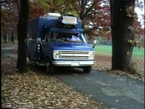
Carnegie Mellon University's Robotics Institute developed the NavLab as an experimental testbed dedicated to autonomous navigation, image understanding, and exploring how humans interact with intelligent mobile systems. Built inside a heavily modified, roadworthy commercial truck, the vehicle serves as a completely mobile navigation habitat. By bringing both the research team and substantial computing power directly inside the vehicle, the system circumvents the traditional pitfalls of early autonomous robotics. As the narrator explains, “Because it is self-contained, the NavLab is not subject to telemetry bottlenecks, communication faults, or dependence on stationary infrastructure, and can travel to confront navigation problems at a test site.”
Inside the vehicle shell, the platform integrates all required hardware, including onboard computers, specialized controllers, telemetry gear, and internal sensors. The interior functions as an onboard laboratory where researchers can monitor telemetry, analyze experimental data, and supervise autonomous operations from an operator's console. For safety and operational flexibility, the vehicle retains standard manual driver controls, allowing a human operator to take over steering and propulsion whenever necessary. As the narrator notes, “The Nav Lab is a roadworthy truck modified so that researchers or computers can control the vehicle as occasion demands.”
- **Core Research Domains:** Robot navigation, computer vision/image understanding, and human-machine interaction with intelligent systems. - **Onboard Cabin Capabilities:** Houses internal computing infrastructure, hardware controllers, monitoring consoles, and passenger workspace for data collection and runtime parameter tuning. - **Human Override Functions:** Manual steering and pedal controls allow human intervention for overland travel between sites, initial system setup, and immediate recovery from experimental errors.
---
[01:14](https://www.youtube.com/watch?v=ntIczNQKfjQ&t=74s) Sensor Suite, Perception, and the Blackboard Architecture
To accommodate a wide spectrum of autonomous vehicle research, the NavLab is outfitted with multimodal sensing hardware. Video cameras capture color and intensity imagery to facilitate scene interpretation. Algorithms analyze road boundaries and surface changes by segmenting intensity, texture, and color variations. In parallel, an active scanning rangefinder sweeps the surrounding terrain using a distance-measuring laser, generating high-fidelity three-dimensional spatial data that captures both the geometric profile and the surface reflectivity of the environment.
Rather than relying on isolated streams, the vehicle combines these disparate perceptual feeds into a coherent world model. The narrator emphasizes, “Taken together, color, intensity, range, and reflectance data provide a rich basis for building natural scene descriptions.” To tie these components together computationally, the platform utilizes a centralized Blackboard software framework. The narrator summarizes this control structure by stating, “A Blackboard computer architecture integrates the distributed processes that sense, map, plan, and drive.”
```mermaid flowchart TD accTitle: NavLab Autonomous Architecture accDescr: Data flow from raw sensor inputs through perceptual fusion into the Blackboard architecture to control driving.
subgraph Sensors["Sensing Modalities"] CAM["Video Cameras<br/>(Color & Intensity)"] LIDAR["Scanning Rangefinder<br/>(Laser Range & Reflectance)"] end
subgraph Perception["Data Fusion"] FEAT["Road Segmentation &<br/>3D Geometric Models"] end
subgraph Core["Blackboard Architecture"] BB[("Blackboard Shared Memory")] MAP["Mapping Process"] PLAN["Planning Process"] DRIVE["Driving & Actuation"] end
CAM --> FEAT LIDAR --> FEAT FEAT --> BB BB <--> MAP BB <--> PLAN PLAN --> DRIVE ```
- **Perceptual Processing:** Video inputs identify lane margins and obstacles using color, texture, and intensity segmentation. - **Laser Rangefinding:** Provides geometric depth measurements alongside material reflectance to understand surface profiles in 3D. - **Distributed Software Framework:** The Blackboard system coordinates asynchronous, distributed subroutines responsible for sensing, mapping, path planning, and physical actuation.
## Notable quotes > [01:14](https://www.youtube.com/watch?v=ntIczNQKfjQ&t=74s) Taken together, color, intensity, range, and reflectance data provide a rich basis for building natural scene descriptions. — narrator
> [00:00](https://www.youtube.com/watch?v=ntIczNQKfjQ&t=0s) Because it is self-contained, the NavLab is not subject to telemetry bottlenecks, communication faults, or dependence on stationary infrastructure, and can travel to confront navigation problems at a test site. — narrator
## Mentioned Carnegie Mellon University, Robotics Institute, NavLab, NavLab 1, Blackboard
## Video description NavLab or Navigation Laboratory was the first self-driving car with people riding on board. It was very slow, but for 1986 computing power, it was revolutionary. NavLab continued to lay the groundwork for Carnegie Mellon University's expertise in the field of autonomous vehicles.
https://en.wikipedia.org/wiki/Navlab
[Source](https://www.youtube.com/watch?v=ntIczNQKfjQ)